Plattsburgh, New York.
I think this was a spur line at one point, but i presume it has been out of service for maybe one or two decades... Small portion of the line serves an Amerigas plant but that's pretty much it!
First crossing, Google Earth image due to no street view coverage, looks to be a passive crossing to the looks of it.
https://www.google.com/maps/@44.6356719 ... a=!3m1!1e3
Looks like the line has been gone for at least
nearly thirty years!
https://www.google.com/maps/@44.6411709 ... 312!8i6656
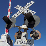
Here is a bit of a beaten up WRRS installation, though i'm not sure why DelDOT resurfaced the stop lines to an out of service crossing.
https://www.google.com/maps/@44.6425871 ... 312!8i6656
Not to mention, the RXR approach lines!
https://www.google.com/maps/@44.6415345 ... 312!8i6656
Can't tell if this is a RACO signal, though the relay case is from GRS, so i'm not surprised if it was a knock-down replacement, one light has a trimmed visor so it could be either a Safetran or GRS 8 inch light.
https://www.google.com/maps/@44.6520076 ... 312!8i6656
Not sure what gave CP the opportunity to replace the DOT tags here, i'm not gonna bother assuming they were attempting to bring the line back into service.
https://www.google.com/maps/@44.6552786 ... 312!8i6656
GRS 8 Inch lights that have fell victim to scrap metal thieves, nice job botching the theft considering wiring is exposed.
https://www.google.com/maps/@44.6592298 ... 312!8i6656
More modernish Safetran 12x20 lights?
https://www.google.com/maps/@44.6593503 ... 312!8i6656
An out of service crossbuck crossing.
https://www.google.com/maps/@44.6644257 ... 312!8i6656
All you see here at the end is vegetation, relay case and what appears to be a corroded signal mast.
https://www.google.com/maps/@44.6629284 ... 312!8i6656