This spur doesn't look like it was used in a long time, vegetation grown up on both sides.
https://www.google.com/maps/@34.5308427 ... 312!8i6656
Tracks out of service
Moderators: freebrickproductions, mlgillson, TommyBNSF, Raco_GS
Re: Tracks out of service
Looks like a double crossing here, with one track being an abandoned spur.
https://www.google.com/maps/@27.4821842 ... 384!8i8192
https://www.google.com/maps/@27.4821842 ... 384!8i8192

Re: Tracks out of service
Found this one in Brookville, PA. Quite nice signals with old crossbucks.
https://www.google.com/maps/@41.148971, ... 312!8i6656
https://www.google.com/maps/@41.148971, ... 312!8i6656
-
Snowpix7911
- Posts: 2
- Joined: Fri Jul 17, 2020 5:34 pm
Re: Tracks out of service
Some interesting crossings from an abandoned line from Sarnia to Chatham-Kent, Ontario.
Bagged up cantilevers with no crossbucks or mast lights.
https://www.instantstreetview.com/@42.4 ... ,13.28p,1z
Lights are gone and the relay case has been opened, probably by a druggie.
https://www.instantstreetview.com/@42.4 ... .98p,0.15z
https://www.instantstreetview.com/@42.4 ... .74p,1.92z
One lonely crossbuck.
https://www.instantstreetview.com/@42.4 ... ,-5.43p,1z
Double track crossing, both ripped up.
https://www.instantstreetview.com/@42.4 ... ,-9.33p,0z
Both signals are on the wrong side!
https://www.instantstreetview.com/@42.5 ... ,-7.56p,1z
Another lonely crossbuck.
https://www.instantstreetview.com/@42.5 ... .51p,0.65z
Double abandoned crossing.
https://www.instantstreetview.com/@42.5 ... 4.9p,1.67z
This is the only crossing on one of the several abandoned spurs along the line.
https://www.instantstreetview.com/@42.5 ... .89p,0.94z
https://www.instantstreetview.com/@42.5 ... .24p,0.09z
Poor old rusty cantilever.
https://www.instantstreetview.com/@42.5 ... h,2.65p,1z
Another lonely crossbuck.
https://www.instantstreetview.com/@42.5 ... ,-6.64p,1z
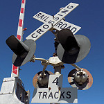
There used to be 3 tracks here.
https://www.instantstreetview.com/@42.5 ... -13.31p,1z
https://www.instantstreetview.com/@42.5 ... ,-0.57p,2z
https://www.instantstreetview.com/@42.5 ... h,2.37p,2z
https://www.instantstreetview.com/@42.5 ... h,2.63p,1z
https://www.instantstreetview.com/@42.5 ... 1h,3.2p,1z
https://www.instantstreetview.com/@42.5 ... .74p,1.02z
The spur is abandoned, along with the rest of the line.
https://www.instantstreetview.com/@42.5 ... ,-5.26p,1z
Nothing left of this crossing on the spur.
https://www.instantstreetview.com/@42.5 ... ,-3.65p,1z
The spur ends right here, going nowhere.
https://www.instantstreetview.com/@42.5 ... ,-4.85p,1z
Another spur, Nothing left of this crossing either.
https://www.instantstreetview.com/@42.5 ... ,-4.62p,0z
Nothing left here either.
https://www.instantstreetview.com/@42.5 ... -11.62p,1z
Back on the main line, featuring some beat-up cantilever signals in the middle of an intersection.
https://www.instantstreetview.com/@42.5 ... 3h,5.9p,1z
The line is cut right here, and the end of the officially abandoned section. The rest of the line is out of service from here.
https://www.instantstreetview.com/@42.6 ... .99p,2.06z
This crossing is now LED, though out of service.
https://www.instantstreetview.com/@42.6 ... ,-5.12p,1z
https://www.instantstreetview.com/@42.6 ... ,-4.58p,1z
https://www.instantstreetview.com/@42.8 ... ,-5.88p,1z
This crossing is now LED as well.
https://www.instantstreetview.com/@42.8 ... 0.29p,0.3z
https://www.instantstreetview.com/@42.8 ... ,-2.22p,1z
https://www.instantstreetview.com/@42.8 ... ,-2.73p,1z
RARE American style crossbucks in Canada!
https://www.instantstreetview.com/@42.9 ... ,-2.64p,1z
https://www.instantstreetview.com/@42.9 ... ,-4.99p,1z
This is the last abandoned crossing on the line, located on a spur. Past here, the line itself is active.
Bagged up cantilevers with no crossbucks or mast lights.
https://www.instantstreetview.com/@42.4 ... ,13.28p,1z
Lights are gone and the relay case has been opened, probably by a druggie.
https://www.instantstreetview.com/@42.4 ... .98p,0.15z
https://www.instantstreetview.com/@42.4 ... .74p,1.92z
One lonely crossbuck.
https://www.instantstreetview.com/@42.4 ... ,-5.43p,1z
Double track crossing, both ripped up.
https://www.instantstreetview.com/@42.4 ... ,-9.33p,0z
Both signals are on the wrong side!
https://www.instantstreetview.com/@42.5 ... ,-7.56p,1z
Another lonely crossbuck.
https://www.instantstreetview.com/@42.5 ... .51p,0.65z
Double abandoned crossing.
https://www.instantstreetview.com/@42.5 ... 4.9p,1.67z
This is the only crossing on one of the several abandoned spurs along the line.
https://www.instantstreetview.com/@42.5 ... .89p,0.94z
https://www.instantstreetview.com/@42.5 ... .24p,0.09z
Poor old rusty cantilever.
https://www.instantstreetview.com/@42.5 ... h,2.65p,1z
Another lonely crossbuck.
https://www.instantstreetview.com/@42.5 ... ,-6.64p,1z
There used to be 3 tracks here.
https://www.instantstreetview.com/@42.5 ... -13.31p,1z
https://www.instantstreetview.com/@42.5 ... ,-0.57p,2z
https://www.instantstreetview.com/@42.5 ... h,2.37p,2z
https://www.instantstreetview.com/@42.5 ... h,2.63p,1z
https://www.instantstreetview.com/@42.5 ... 1h,3.2p,1z
https://www.instantstreetview.com/@42.5 ... .74p,1.02z
The spur is abandoned, along with the rest of the line.
https://www.instantstreetview.com/@42.5 ... ,-5.26p,1z
Nothing left of this crossing on the spur.
https://www.instantstreetview.com/@42.5 ... ,-3.65p,1z
The spur ends right here, going nowhere.
https://www.instantstreetview.com/@42.5 ... ,-4.85p,1z
Another spur, Nothing left of this crossing either.
https://www.instantstreetview.com/@42.5 ... ,-4.62p,0z
Nothing left here either.
https://www.instantstreetview.com/@42.5 ... -11.62p,1z
Back on the main line, featuring some beat-up cantilever signals in the middle of an intersection.
https://www.instantstreetview.com/@42.5 ... 3h,5.9p,1z
The line is cut right here, and the end of the officially abandoned section. The rest of the line is out of service from here.
https://www.instantstreetview.com/@42.6 ... .99p,2.06z
This crossing is now LED, though out of service.
https://www.instantstreetview.com/@42.6 ... ,-5.12p,1z
https://www.instantstreetview.com/@42.6 ... ,-4.58p,1z
https://www.instantstreetview.com/@42.8 ... ,-5.88p,1z
This crossing is now LED as well.
https://www.instantstreetview.com/@42.8 ... 0.29p,0.3z
https://www.instantstreetview.com/@42.8 ... ,-2.22p,1z
https://www.instantstreetview.com/@42.8 ... ,-2.73p,1z
RARE American style crossbucks in Canada!
https://www.instantstreetview.com/@42.9 ... ,-2.64p,1z
https://www.instantstreetview.com/@42.9 ... ,-4.99p,1z
This is the last abandoned crossing on the line, located on a spur. Past here, the line itself is active.
-
brett nc railfanner
- Posts: 591
- Joined: Sun Jun 14, 2015 8:50 am
- Location: San Diego, CA
Re: Tracks out of service
The abandoned portion of the Caldwell County Railroad in Lenoir, NC:
https://www.google.com/maps/@35.9399119 ... 384!8i8192
https://www.google.com/maps/@35.9344008 ... 384!8i8192
https://www.google.com/maps/@35.9267725 ... 312!8i6656
https://www.google.com/maps/@35.9226417 ... 312!8i6656
https://www.google.com/maps/@35.9198715 ... 312!8i6656
https://www.google.com/maps/@35.9161953 ... 312!8i6656
https://www.google.com/maps/@35.9102208 ... 384!8i8192
https://www.google.com/maps/@35.9087683 ... 312!8i6656
https://www.google.com/maps/@35.9085713 ... 312!8i6656
https://www.google.com/maps/@35.8990378 ... 312!8i6656
https://www.google.com/maps/@35.8981155 ... 384!8i8192
https://www.google.com/maps/@35.8969124 ... 312!8i6656
https://www.google.com/maps/@35.8856915 ... 312!8i6656
https://www.google.com/maps/@35.884951, ... 384!8i8192
Re: Tracks out of service
Google Maps shows a crossing here, but apparently the tracks were removed and the crossing repaved at some point. I how long ago? In Pine Mountain, GA:
https://www.google.com/maps/@32.8831741 ... 312!8i6656
Tracks removed here too, at Warm Springs, GA:
https://www.google.com/maps/@32.9174126 ... 312!8i6656
https://www.google.com/maps/@32.8831741 ... 312!8i6656
Tracks removed here too, at Warm Springs, GA:
https://www.google.com/maps/@32.9174126 ... 312!8i6656
-
brett nc railfanner
- Posts: 591
- Joined: Sun Jun 14, 2015 8:50 am
- Location: San Diego, CA
Re: Tracks out of service
The abandoned portion of the Simpson Railroad in Shelton, WA:
https://www.google.com/maps/@47.2092465 ... 384!8i8192
https://www.google.com/maps/@47.2107136 ... 384!8i8192
https://www.google.com/maps/@47.2129491 ... 312!8i6656
https://www.google.com/maps/@47.2137998 ... 384!8i8192
https://www.google.com/maps/@47.2139239 ... 384!8i8192
https://www.google.com/maps/@47.2125306 ... 384!8i8192
https://www.google.com/maps/@47.2296798 ... 328!8i1664

Re: Tracks out of service
Wow. These classics with the old school "RAIL WAY CROSSING" crossbucks actually managed to stay up into 2015.
https://www.google.com/maps/@49.2038842 ... 312!8i6656
https://www.google.com/maps/@49.2036469 ... 312!8i6656
Strangely, I came across these as I traced the line that has long since been turned into a bicycle trail, but was used for the Bus Scene at the beginning of Atomic Train (1999)
https://www.google.com/maps/@49.247618, ... 312!8i6656
By 2017 it was fully converted to a trail. The signals must have been purely props at the location... because the crossbucks and stop signs were in the same location as they were in the movie. Makes me wonder how far unused this line was when they originally filmed the movie.
Well, 
-
brett nc railfanner
- Posts: 591
- Joined: Sun Jun 14, 2015 8:50 am
- Location: San Diego, CA
Re: Tracks out of service
The only crossing on google street view of an abandoned line that once served the Eagle Mountain mine. It has been abandoned due to the mine's closure in 1986.
https://www.google.com/maps/@33.7746201 ... 384!8i8192
https://www.google.com/maps/@33.7746201 ... 384!8i8192
-
brett nc railfanner
- Posts: 591
- Joined: Sun Jun 14, 2015 8:50 am
- Location: San Diego, CA
Re: Tracks out of service
The out of service portion of the Columbia Basin Railroad in Moses Lake, WA:
https://www.google.com/maps/@47.118131, ... 384!8i8192
https://www.google.com/maps/@47.1215784 ... 384!8i8192
https://www.google.com/maps/@47.1322217 ... 384!8i8192
https://www.google.com/maps/@47.142419, ... 312!8i6656
https://www.google.com/maps/@47.1458212 ... 384!8i8192
https://www.google.com/maps/@47.1458195 ... 384!8i8192
https://www.google.com/maps/@47.146902, ... 384!8i8192
https://www.google.com/maps/@47.1531198 ... 384!8i8192
https://www.google.com/maps/@47.1615509 ... 384!8i8192
https://www.google.com/maps/@47.1777405 ... 384!8i8192
https://www.google.com/maps/@47.1781749 ... 312!8i6656
https://www.google.com/maps/@47.1782071 ... 384!8i8192
https://www.google.com/maps/@47.1821449 ... 384!8i8192
https://www.google.com/maps/@47.1842292 ... 384!8i8192
https://www.google.com/maps/@47.1860684 ... 384!8i8192