Hardin, KY:
https://www.google.com/maps/@36.7616327 ... 312!8i6656
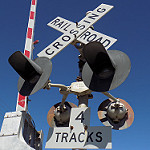
The lone signal also has a relay case on the bottom signal and a US&S Teardrop!!! Though the rails have long since been removed.
Tracks out of service
Moderators: freebrickproductions, mlgillson, TommyBNSF, Raco_GS
-
Ethan the Railfanner

- Posts: 230
- Joined: Wed Feb 14, 2018 7:22 pm
- Location: Hendersonville, Tennessee
Re: Tracks out of service
Ethan the Railfanner; The main railroad crossing photographer of Southeast United States.
If you have any crossing photos that you would like for submissions:
DM me on the forum
DM me on Discord (ethantherailfanner)
If you have any crossing photos that you would like for submissions:
DM me on the forum
DM me on Discord (ethantherailfanner)
-
NathanFromEngland

- Posts: 2369
- Joined: Sat Apr 29, 2017 3:52 pm
- Location: Merseyside
Re: Tracks out of service
Hardin Southern Railroad, according to some information it was last used in 2005 by a single passenger train, apparently someone leased the line to the KWT Railway to serve an industrial park in Murray, don't think it ever materialised so the line sat dormant until the tracks were removed in August 2009.Ethan the Railfanner wrote: ↑Sat Sep 21, 2019 4:52 pmHardin, KY:
https://www.google.com/maps/@36.7616327 ... 312!8i6656
The lone signal also has a relay case on the bottom signal and a US&S Teardrop!!! Though the rails have long since been removed.
As for the website, it sat dormant for pretty much many years after winding down operations at the end of 2004, the site went offline towards the end of 2017.
https://web.archive.org/web/20170922181 ... /hsrr.com/
You can see the HSRR name on the crossbuck crossing to the west.
https://www.google.com/maps/@36.7602731 ... 328!8i1664
This passive crossing to the east of your link still retains the crossbucks, though keep in mind this image is 5 years old, so it may all be gone now.
https://www.google.com/maps/@36.7644829 ... 312!8i6656
Looks like the road was resurfaced over and the tracks towards the crossing were removed prior to when Street View crossed. The line presumably ends here, though i technically got lost looking through the vast vegetation.
https://www.google.com/maps/@36.7674632 ... 328!8i1664
Nothing here.
https://www.google.com/maps/@36.7499037 ... 312!8i6656
Street view came through too late. Not sure if this crossing was signalized or not as it looks like the equipment was already removed.
https://www.google.com/maps/@36.7424506 ... 328!8i1664
Unprotected crossing
https://www.google.com/maps/@36.6955395 ... 312!8i6656
Another passive crossing with HSRR branding visible, probably most likely now gone.
https://www.google.com/maps/@36.692571, ... 328!8i1664
Not sure if there even was a crossing here, but the surface is way different. From there, the line just seemingly ends.
https://www.google.com/maps/@36.6539409 ... a=!3m1!1e3
-
NathanFromEngland
- Posts: 2369
- Joined: Sat Apr 29, 2017 3:52 pm
- Location: Merseyside
Re: Tracks out of service
Brunswick, Georgia.
https://www.google.com/maps/@31.1347051 ... 312!8i6656
https://www.google.com/maps/@31.1347051 ... 312!8i6656
-
Ethan the Railfanner
- Posts: 230
- Joined: Wed Feb 14, 2018 7:22 pm
- Location: Hendersonville, Tennessee
Re: Tracks out of service
North Wilkesboro, NC:
https://www.google.com/maps/@36.1586198 ... 312!8i6656
What appears to be an old SOU install:
https://www.google.com/maps/@36.1580075 ... 312!8i6656
Same for this one:
https://www.google.com/maps/@36.1601195 ... 312!8i6656
https://www.google.com/maps/@36.1586198 ... 312!8i6656
What appears to be an old SOU install:
https://www.google.com/maps/@36.1580075 ... 312!8i6656
Same for this one:
https://www.google.com/maps/@36.1601195 ... 312!8i6656
Ethan the Railfanner; The main railroad crossing photographer of Southeast United States.
If you have any crossing photos that you would like for submissions:
DM me on the forum
DM me on Discord (ethantherailfanner)
If you have any crossing photos that you would like for submissions:
DM me on the forum
DM me on Discord (ethantherailfanner)

Re: Tracks out of service
When I was in Richmond, VA last week, I managed to see these:
https://www.google.com/maps/@37.5667769 ... 312!8i6656
https://www.google.com/maps/@37.5667769 ... 312!8i6656
https://www.google.com/maps/@37.5667769 ... 312!8i6656
https://www.google.com/maps/@37.5667769 ... 312!8i6656
Crossing pictures from Plant City, FL are finally here! viewtopic.php?f=13&t=2538
-
freebrickproductions

- Posts: 8481
- Joined: Thu Jun 07, 2012 11:12 am
- Location: Huntsville, AL
- Contact:
Re: Tracks out of service
A fair few abandoned crossings in Kokomo, IN:
They/Them for me, please.
Click here if you want to submit crossing photos to the site!
Avatar by runesprite on Twitter.
Click here if you want to submit crossing photos to the site!
Avatar by runesprite on Twitter.
Re: Tracks out of service
Haven't we talked about the crossings in Kokomo before, though?freebrickproductions wrote: ↑Wed Oct 02, 2019 12:53 amA fair few abandoned crossings in Kokomo, IN:
Crossing pictures from Plant City, FL are finally here! viewtopic.php?f=13&t=2538
-
freebrickproductions
- Posts: 8481
- Joined: Thu Jun 07, 2012 11:12 am
- Location: Huntsville, AL
- Contact:
Re: Tracks out of service
I think some different ones.ZachL wrote: ↑Sun Oct 06, 2019 2:09 pmHaven't we talked about the crossings in Kokomo before, though?freebrickproductions wrote: ↑Wed Oct 02, 2019 12:53 amA fair few abandoned crossings in Kokomo, IN:
They/Them for me, please.
Click here if you want to submit crossing photos to the site!
Avatar by runesprite on Twitter.
Click here if you want to submit crossing photos to the site!
Avatar by runesprite on Twitter.
Re: Tracks out of service
Now here's something odd. The last crossing on a little-used line has mast signals, but poles for huge cantilevers. There is one customer between this crossing and the end of the line at the GSP, but their spur doesn't look active. Maybe they are or were planning to widen the road. Rails do look like that might get light use, judging by condition of top of rail.
https://www.google.com/maps/@39.3999901 ... 312!8i6656
https://www.google.com/maps/@39.3999901 ... 312!8i6656
-
brett nc railfanner
- Posts: 591
- Joined: Sun Jun 14, 2015 8:50 am
- Location: San Diego, CA
Re: Tracks out of service
An abandoned spur in Greenville, North Carolina:
https://www.google.com/maps/@35.6452058 ... 312!8i6656
Another abandoned spur in Greenville, North Carolina:
https://www.google.com/maps/@35.6525323 ... 312!8i6656
A cutoff crossing in Edenton, North Carolina:
https://www.google.com/maps/@36.0598471 ... 312!8i6656
Proof that it was cutoff:
https://www.google.com/maps/@36.059806, ... 312!8i6656
Going down the line:
https://www.google.com/maps/@36.0588267 ... 312!8i6656
https://www.google.com/maps/@36.0570127 ... 312!8i6656
The only remnants of the line past that are paved over grades.