Here is some on an abandoned Norfolk Southern line. Some of these crossings are now gone due to the new Tide Light Rail system. Theres still a huge chunk of the line abandoned though. An asterisk (*) means this crossing has been upgraded as part of the Tide Light Rail system. An R (R) means these signals were not affected by the Tide Light Rail project but were removed. The rest of the line was converted into a trail IIRC
Note: Crossings with no equipment or that do not have a streetview are not included
Not sure why this crossing is basically gateless, might've just been a switching line or something. (R)
https://www.google.co.uk/maps/@36.84607 ... 328!8i1664
Another crossing that appears to be a 1980's NS install. (*)
https://www.google.co.uk/maps/@36.84647 ... 328!8i1664
1960's WRRS signals? (*)
https://www.google.co.uk/maps/@36.84254 ... 328!8i1664
Crossbuck crossing. (*)
https://www.google.co.uk/maps/@36.84142 ... 328!8i1664
Another 1980's NS install. (*)
https://www.google.co.uk/maps/@36.84163 ... 328!8i1664
Crossing with Safetran 12x20 inch lights, not sure if they upgraded these signals when the line was abandoned or not long before abandonment (*)
https://www.google.co.uk/maps/@36.84126 ... 328!8i1664
Crossbuck crossing (*) Kinda odd where the crossbuck where GSV went past it is placed.
https://www.google.co.uk/maps/@36.84149 ... 328!8i1664
Another crossbuck crossing (*)
https://www.google.co.uk/maps/@36.84126 ... 328!8i1664
Some Safetran lights that appear to have replaced WRRS lights. (*)
https://www.google.co.uk/maps/@36.84098 ... 328!8i1664
Is this a WRRS mechanical bell?
https://www.google.co.uk/maps/@36.84098 ... 3328!8i166
1980's NS install (R) just right next to the terminus.
https://www.google.co.uk/maps/@36.84089 ... 328!8i1664
This crossing used to have gates! (R)
https://www.google.co.uk/maps/@36.84078 ... 328!8i1664
RACO installation? (R)
https://www.google.co.uk/maps/@36.84078 ... 328!8i1664
Open crossing, not sure why but one of these signals is mounted on a block. (R)
https://www.google.co.uk/maps/@36.84065 ... 328!8i1664
This crossing used to have gates too!
https://www.google.co.uk/maps/@36.84071 ... 328!8i1664
Kinda newish signals (R)
https://www.google.co.uk/maps/@36.84021 ... 328!8i1664
This 2011 streetview shows a Safetran cantilever, a Safetran mechanical bell and 2 pairs of Safetran 12x20 inch lights, the other signal must've been struck by a vehicle. (R)
https://www.google.co.uk/maps/@36.84032 ... 312!8i6656
4 cantilevers on one crossing! (R)
https://www.google.co.uk/maps/@36.83989 ... 328!8i1664
This crossing at first glance looked to be a bell only crossing, but i got suspicious when i saw wires. A 2007 street view shows Safetran 12x24 inch lights that looked to have been removed by scrap metal thieves. The grade looked to have also been renewed in recent years. (R)
https://www.google.co.uk/maps/@36.83993 ... 312!8i6656
https://www.google.co.uk/maps/@36.83994 ... 328!8i1664
Combination of Safetran 12x24 inch lights and Safetran 8 inch lights. (R)
By 2011, only one cantilever was standing.
https://www.google.co.uk/maps/@36.84017 ... 312!8i6656
Abandoned crossbuck crossing (I presume this has been removed, it only shows a July 2011 street view)
https://www.google.co.uk/maps/@36.83970 ... 312!8i6656
1980's NS installation (R)
https://www.google.co.uk/maps/@36.83953 ... 312!8i6656
A crossbuck which has had a plant grow on the top of it! (R)
https://www.google.co.uk/maps/@36.83991 ... 312!8i6656
Late 1990's NS installation, it has a GS type 1 E-Bell! (R)
https://www.google.co.uk/maps/@36.83955 ... 312!8i6656
Another 1980's NS installation. (R)
https://www.google.co.uk/maps/@36.83991 ... 328!8i1664
Another late 1990's NS installation, removed presumably in late 2015.
https://www.google.co.uk/maps/@36.83972 ... 312!8i6656
Some very old cantilevers!
https://www.google.co.uk/maps/@36.83959 ... 312!8i6656
Very early Safetran installation, the mechanical bell was stolen! (R)
https://www.google.co.uk/maps/@36.83928 ... 312!8i6656
Old installation that was still there in October 2015, but gone by March 2016.
https://www.google.co.uk/maps/@36.83916 ... 312!8i6656
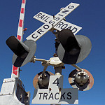
Crossbuck crossing that appears to have two tracks, but i can only see one. (R)
https://www.google.co.uk/maps/@36.83863 ... 312!8i6656
WRRS signals.
https://www.google.co.uk/maps/@36.83850 ... 312!8i6656
Late 1990's NS installation. (R)
https://www.google.co.uk/maps/@36.83825 ... 328!8i1664
After that crossing, the line ends.