Abandoned spur in Fremont, NE:
https://www.google.com/maps/@41.4283756 ... 312!8i6656
An abandoned UP line in Fremont, NE:
This first crossing had a pair of old C&NW-era Griswold cantilevers:
https://www.google.com/maps/@41.4364822 ... 312!8i6656
All that's left currently is the relay case, though:
https://www.google.com/maps/@41.4364813 ... 312!8i6656
This crossing is also the on the site:
http://www.rxrsignals.com/Nebraska/Fremont/Military2/
Some gated WCH signals with a Safetran bell, which I believe have since been removed:
https://www.google.com/maps/@41.4420722 ... 312!8i6656
To the north of here, the line becomes the out-of-service Fremont & Elkhorn Valley Railroad (since renamed the Fremont Northern Railroad, but never regaining operations). Here's their old headquarters:
https://www.google.com/maps/@41.447133, ... 312!8i6656
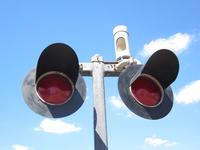
Continuing north, we find this very classic pair of 8 inch gateless signals from the C&NW:
https://www.google.com/maps/@41.4514082 ... 312!8i6656
Another pair of classic C&NW signals, complete with cats-eye crossbucks and a rain-shieldless mechanical bell!
https://www.google.com/maps/@41.4531777 ... 312!8i6656
At Broad Street, we find that there had been a pair of newer gated signals installed by the FEVR:
https://www.google.com/maps/@41.4581559 ... 312!8i6656
By 2015, the lights were bagged and the gates were removed:
https://www.google.com/maps/@41.4581362 ... 312!8i6656
And by 2018, all that's left is the relay case:
https://www.google.com/maps/@41.4580791 ... 312!8i6656
Continuing north, we find a crossbuck crossing:
https://www.google.com/maps/@41.4634322 ... 312!8i6656
Followed by another one:
https://www.google.com/maps/@41.4659257 ... 328!8i1664
At US 30, we find a crossing with a bit of an interesting history.
In 2007 and prior, the crossing was protected by just this pair of older gated signals:
https://www.google.com/maps/@41.4757192 ... 328!8i1664
However, in 2007, the highway was being widened to a four-lane divided highway, so the new then-future-eastbound half of the road was being guarded by a pair of newer gated signals:
https://www.google.com/maps/@41.4759191 ... 328!8i1664
By 2009, work had completed on the widening, and the crossing now had a "proper" gated install for the four-lane divided highway:
https://www.google.com/maps/@41.475745, ... 328!8i1664
No major changes had occurred by 2012, though the signals were starting to look a bit more aged:
https://www.google.com/maps/@41.4759,-9 ... 312!8i6656
Same goes for 2014:
https://www.google.com/maps/@41.4758728 ... 312!8i6656
By 2015, the lights were bagged and the gates were removed:
https://www.google.com/maps/@41.4757778 ... 312!8i6656
In 2016, the crossing was in the process of being torn out and the signals were removed:
https://www.google.com/maps/@41.4758556 ... 312!8i6656
And in 2018, all that's left of the crossing is the lone relay case:
https://www.google.com/maps/@41.4759043 ... 312!8i6656
Continuing north, we find another pair of crossbucks:
https://www.google.com/maps/@41.4804237 ... 328!8i1664
Up in Nickerson, we find this pair of newer WCH signals, one of which is gateless while the other is gated:
https://www.google.com/maps/@41.5385296 ... 312!8i6656
The reason for the set-up was that, originally, this had been a double-crossing with the nearby BNSF line:
https://www.google.com/maps/@41.5385244 ... 312!8i6656
However, after the FEVR line went out of service, BNSF upgraded their signals to a pair of gated signals, since the FEVR ones were likely shut-off:
https://www.google.com/maps/@41.5385272 ... 312!8i6656
Interestingly enough, the FEVR crossing still has a power connection, so I wonder if the signals could still work?
https://www.google.com/maps/@41.5385292 ... 312!8i6656
Up closer to Hooper, the line peels away from the BNSF, and we find this pair of newer gated signals at US 77:
https://www.google.com/maps/@41.5995804 ... 312!8i6656
By 2014, one of the signals had already lost its gate mech and arm:
https://www.google.com/maps/@41.5995235 ... 312!8i6656
And by 2018, the crossing was removed entirely with only the relay case remaining:
https://www.google.com/maps/@41.5995108 ... 312!8i6656
Continuing into Hooper, we find more crossbucks:
https://www.google.com/maps/@41.6084065 ... 312!8i6656
https://www.google.com/maps/@41.6095145 ... 312!8i6656
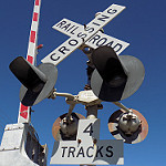
Followed by this very classic pair of C&NW signals:
https://www.google.com/maps/@41.6103825 ... 312!8i6656
Which are also on the site:
http://www.rxrsignals.com/Nebraska/Hooper/Main/
And then more crossbucks:
https://www.google.com/maps/@41.6109718 ... 312!8i6656
And then finally, here's the end of the line:
https://www.google.com/maps/@41.6123315 ... 312!8i6656
Tracks out of service
Moderators: freebrickproductions, mlgillson, TommyBNSF, Raco_GS
-
freebrickproductions

- Posts: 8532
- Joined: Thu Jun 07, 2012 11:12 am
- Location: Huntsville, AL
- Contact:
Re: Tracks out of service
They/Them for me, please.
Click here if you want to submit crossing photos to the site!
Avatar by runesprite on Twitter.
Click here if you want to submit crossing photos to the site!
Avatar by runesprite on Twitter.
-
NathanFromEngland

- Posts: 2370
- Joined: Sat Apr 29, 2017 3:52 pm
- Location: Merseyside
Re: Tracks out of service
I'm surprised how in the images on the page that the relay case was still recieving power! Either the battery eventually died for the crossing or the crossing was disconnected. It was probably already OOS back in 2007!freebrickproductions wrote: ↑Fri Jul 05, 2019 11:04 amThis crossing is also the on the site:
http://www.rxrsignals.com/Nebraska/Fremont/Military2/
I can confirm this.freebrickproductions wrote:Some gated WCH signals with a Safetran bell, which I believe have since been removed:
https://www.google.com/maps/@41.4420722 ... 312!8i6656
https://www.google.com/maps/@41.4422263 ... a=!3m1!1e3
The crossing is still there as of 2018!freebrickproductions wrote:Continuing north, we find this very classic pair of 8 inch gateless signals from the C&NW:
https://www.google.com/maps/@41.4514082 ... 312!8i6656
https://www.google.com/maps/@41.4514219 ... 312!8i6656
Not trying to debunk you here, but i think this crossing was initally incandescent until the lights seemed to be upgraded.freebrickproductions wrote:At Broad Street, we find that there had been a pair of newer gated signals installed by the FEVR:
https://www.google.com/maps/@41.4581559 ... 312!8i6656
By 2015, the lights were bagged and the gates were removed:
https://www.google.com/maps/@41.4581362 ... 312!8i6656
And by 2018, all that's left is the relay case:
https://www.google.com/maps/@41.4580791 ... 312!8i6656
https://www.google.com/maps/@41.4581547 ... 328!8i1664
https://www.google.com/maps/@41.458305, ... 328!8i1664
This crossbuck was also installed incorrectly.
https://www.google.com/maps/@41.4581559 ... 312!8i6656
I don't recall these lights being original, but who made these lights, i've never seen flat light backings beforefreebrickproductions wrote:No major changes had occurred by 2012, though the signals were starting to look a bit more aged:
https://www.google.com/maps/@41.4759,-9 ... 312!8i6656
https://www.google.com/maps/@41.4757322 ... 312!8i6656
I also can't imagine if the crossing was even active for that long either, the only time i believe i could see the power light working was 2007 and 2009.
https://www.google.com/maps/@41.4757474 ... 328!8i1664
https://www.google.com/maps/@41.475745, ... 328!8i1664
By 2012, either the light had failed (burned out) or the crossing was shut off.
https://www.google.com/maps/@41.4757825 ... 312!8i6656
In 2007, the FEVR crossing had a pair of Griswold signals! One being ungated and the other an EM gate mechanism!freebrickproductions wrote:Up in Nickerson, we find this pair of newer WCH signals, one of which is gateless while the other is gated:
https://www.google.com/maps/@41.5385296 ... 312!8i6656
The reason for the set-up was that, originally, this had been a double-crossing with the nearby BNSF line:
https://www.google.com/maps/@41.5385244 ... 312!8i6656
However, after the FEVR line went out of service, BNSF upgraded their signals to a pair of gated signals, since the FEVR ones were likely shut-off:
https://www.google.com/maps/@41.5385272 ... 312!8i6656
Interestingly enough, the FEVR crossing still has a power connection, so I wonder if the signals could still work?
https://www.google.com/maps/@41.5385292 ... 312!8i6656
https://www.google.com/maps/@41.5384865 ... 328!8i1664
Strangely enough in 2012, the FEVR crossing was in action alongside the BNSF crossing!
https://www.google.com/maps/@41.5384994 ... 312!8i6656
Refer to me as 'Nari' - She/They are my preferred pronouns
-
freebrickproductions
- Posts: 8532
- Joined: Thu Jun 07, 2012 11:12 am
- Location: Huntsville, AL
- Contact:
Re: Tracks out of service
NathanFromEngland wrote: ↑Fri Jul 05, 2019 11:38 amThe crossing is still there as of 2018!freebrickproductions wrote:Continuing north, we find this very classic pair of 8 inch gateless signals from the C&NW:
https://www.google.com/maps/@41.4514082 ... 312!8i6656
https://www.google.com/maps/@41.4514219 ... 312!8i6656
Ah. Couldn't access the 2007 imagery for some reason (same with several other crossings).NathanFromEngland wrote: ↑Fri Jul 05, 2019 11:38 amNot trying to debunk you here, but i think this crossing was initally [sic] incandescent until the lights seemed to be upgraded.freebrickproductions wrote:At Broad Street, we find that there had been a pair of newer gated signals installed by the FEVR:
https://www.google.com/maps/@41.4581559 ... 312!8i6656
By 2015, the lights were bagged and the gates were removed:
https://www.google.com/maps/@41.4581362 ... 312!8i6656
And by 2018, all that's left is the relay case:
https://www.google.com/maps/@41.4580791 ... 312!8i6656
https://www.google.com/maps/@41.4581547 ... 328!8i1664
https://www.google.com/maps/@41.458305, ... 328!8i1664
This crossbuck was also installed incorrectly.
https://www.google.com/maps/@41.4581559 ... 312!8i6656
And yes, the crossing was incandescent. Interestingly enough, the signal with the bell was replaced between 2009 and 2012, probably why the crossing was given an LED upgrade:
https://www.google.com/maps/@41.4582669 ... 312!8i6656
Those are from Progress Rail.NathanFromEngland wrote: ↑Fri Jul 05, 2019 11:38 amI don't recall these lights being original, but who made these lights, i've never seen flat light backings before
https://www.google.com/maps/@41.4757322 ... 312!8i6656
I think I remember that Griswold set-up, didn't realize it was that crossing.NathanFromEngland wrote: ↑Fri Jul 05, 2019 11:38 amIn 2007, the FEVR crossing had a pair of Griswold signals! One being ungated and the other an EM gate mechanism!freebrickproductions wrote:Up in Nickerson, we find this pair of newer WCH signals, one of which is gateless while the other is gated:
https://www.google.com/maps/@41.5385296 ... 312!8i6656
The reason for the set-up was that, originally, this had been a double-crossing with the nearby BNSF line:
https://www.google.com/maps/@41.5385244 ... 312!8i6656
However, after the FEVR line went out of service, BNSF upgraded their signals to a pair of gated signals, since the FEVR ones were likely shut-off:
https://www.google.com/maps/@41.5385272 ... 312!8i6656
Interestingly enough, the FEVR crossing still has a power connection, so I wonder if the signals could still work?
https://www.google.com/maps/@41.5385292 ... 312!8i6656
https://www.google.com/maps/@41.5384865 ... 328!8i1664
Strangely enough in 2012, the FEVR crossing was in action alongside the BNSF crossing!
https://www.google.com/maps/@41.5384994 ... 312!8i6656
And as I mentioned, it was installed as a double-crossing set-up, so both crossing's would've activated for any BNSF trains going through prior to BNSF upgrading their crossing.
They/Them for me, please.
Click here if you want to submit crossing photos to the site!
Avatar by runesprite on Twitter.
Click here if you want to submit crossing photos to the site!
Avatar by runesprite on Twitter.
Re: Tracks out of service
Is there any way we could fix the truncated links being broken in quotes?
Crossing pictures from Plant City, FL are finally here! viewtopic.php?f=13&t=2538
-
freebrickproductions
- Posts: 8532
- Joined: Thu Jun 07, 2012 11:12 am
- Location: Huntsville, AL
- Contact:
Re: Tracks out of service
Not sure, it appears to be an issue on Nathan's end, given how when I quoted his post the links he gave worked fine.
They/Them for me, please.
Click here if you want to submit crossing photos to the site!
Avatar by runesprite on Twitter.
Click here if you want to submit crossing photos to the site!
Avatar by runesprite on Twitter.
-
freebrickproductions
- Posts: 8532
- Joined: Thu Jun 07, 2012 11:12 am
- Location: Huntsville, AL
- Contact:
Re: Tracks out of service
San Leandro, CA:
https://www.google.com/maps/@37.693333, ... 384!8i8192
https://www.google.com/maps/@37.693333, ... 384!8i8192
They/Them for me, please.
Click here if you want to submit crossing photos to the site!
Avatar by runesprite on Twitter.
Click here if you want to submit crossing photos to the site!
Avatar by runesprite on Twitter.
-
NathanFromEngland
- Posts: 2370
- Joined: Sat Apr 29, 2017 3:52 pm
- Location: Merseyside
Re: Tracks out of service
Alma, Michigan.
https://www.google.com/maps/@43.3762891 ... 312!8i6656
https://www.google.com/maps/@43.3762891 ... 312!8i6656
Switch
https://www.google.com/maps/@43.3761213 ... 312!8i6656
By 2016 sidewalks were built over some of the trackage and the trackbed was resurfaced over.
https://www.google.com/maps/@43.3761253 ... 312!8i6656
The signal here, was also moved and the track sign corrected.
https://www.google.com/maps/@43.3761253 ... 312!8i6656
https://www.google.com/maps/@43.3762891 ... 312!8i6656
https://www.google.com/maps/@43.3762891 ... 312!8i6656
Switch
https://www.google.com/maps/@43.3761213 ... 312!8i6656
By 2016 sidewalks were built over some of the trackage and the trackbed was resurfaced over.
https://www.google.com/maps/@43.3761253 ... 312!8i6656
The signal here, was also moved and the track sign corrected.
https://www.google.com/maps/@43.3761253 ... 312!8i6656
Refer to me as 'Nari' - She/They are my preferred pronouns
Re: Tracks out of service
And in 2015 you can see the tracks removed before repaving:NathanFromEngland wrote: ↑Sat Jul 20, 2019 8:26 amAlma, Michigan.
https://www.google.com/maps/@43.3762891 ... 312!8i6656
https://www.google.com/maps/@43.3762891 ... 312!8i6656
Switch
https://www.google.com/maps/@43.3761213 ... 312!8i6656
By 2016 sidewalks were built over some of the trackage and the trackbed was resurfaced over.
https://www.google.com/maps/@43.3761253 ... 312!8i6656
The signal here, was also moved and the track sign corrected.
https://www.google.com/maps/@43.3761253 ... 312!8i6656
https://www.google.com/maps/@43.3762753 ... 312!8i6656
Crossing pictures from Plant City, FL are finally here! viewtopic.php?f=13&t=2538
-
brett nc railfanner
- Posts: 591
- Joined: Sun Jun 14, 2015 8:50 am
- Location: San Diego, CA

Re: Tracks out of service
And yet it appears they cleared a bit of brush to store some rail cars yet up to the highway.
Well, 