Huh???
https://www.google.com/maps/@46.2459867 ... 312!8i6656
Google Maps Scavenger Hunt
Moderators: freebrickproductions, mlgillson, TommyBNSF, Raco_GS
-
NathanFromEngland

- Posts: 2369
- Joined: Sat Apr 29, 2017 3:52 pm
- Location: Merseyside
-
freebrickproductions

- Posts: 8480
- Joined: Thu Jun 07, 2012 11:12 am
- Location: Huntsville, AL
- Contact:
Re: Google Maps Scavenger Hunt
Looks like an older WCH, though it might be WRRS or Federal Signal. Would need to see the back. I'm betting WCH though.Erik-Gorb-Hamilton wrote:This crossing is the last crossing on the ENTIRE BNSF Seattle Subdivision to have a mechanical bell anywhere. If you google street viewed all other crossings on the BNSF they would be all E-Bells. The UP, However, still has a plethora of Safetran M-Bells at their crossings. It is my goal one day to get the bell of this crossing when the maintainers finally bring it down. The bell would have to be restored as I haven't heard it run in my life. I've also had trouble identifying this bell. Could anyone figure out what type of mechanical bell this is?
Thank you!
They/Them for me, please.
Click here if you want to submit crossing photos to the site!
Avatar by runesprite on Twitter.
Click here if you want to submit crossing photos to the site!
Avatar by runesprite on Twitter.
-
ToledoRailfan
- No Longer Associated With The Forum
- Posts: 3315
- Joined: Sun Jul 21, 2013 2:38 pm
Re: Google Maps Scavenger Hunt
The traffic signals being attached to the cantilever is pretty interesting. I wonder what this is for? Maybe it is some sort of junction box?Erik-Gorb-Hamilton wrote:This crossing is the last crossing on the ENTIRE BNSF Seattle Subdivision to have a mechanical bell anywhere. If you google street viewed all other crossings on the BNSF they would be all E-Bells. The UP, However, still has a plethora of Safetran M-Bells at their crossings. It is my goal one day to get the bell of this crossing when the maintainers finally bring it down. The bell would have to be restored as I haven't heard it run in my life. I've also had trouble identifying this bell. Could anyone figure out what type of mechanical bell this is?
Thank you!
-
ToledoRailfan
- No Longer Associated With The Forum
- Posts: 3315
- Joined: Sun Jul 21, 2013 2:38 pm
Re: Google Maps Scavenger Hunt
That is pretty odd!NathanFromEngland wrote:Huh???
https://www.google.com/maps/@46.2459867 ... 312!8i6656
-
Erik-Gorb-Hamilton

- Posts: 180
- Joined: Wed Jun 07, 2017 12:25 am
Re: Google Maps Scavenger Hunt
Friday is coming up and that is when dad has off so I'll see if i can check it out. WCH Is mixed along with the Safetrans on the UP so they are quite common. Now if it was a WRRS or Federal Signal bell then I would be happy!freebrickproductions wrote:Looks like an older WCH, though it might be WRRS or Federal Signal. Would need to see the back. I'm betting WCH though.Erik-Gorb-Hamilton wrote:This crossing is the last crossing on the ENTIRE BNSF Seattle Subdivision to have a mechanical bell anywhere. If you google street viewed all other crossings on the BNSF they would be all E-Bells. The UP, However, still has a plethora of Safetran M-Bells at their crossings. It is my goal one day to get the bell of this crossing when the maintainers finally bring it down. The bell would have to be restored as I haven't heard it run in my life. I've also had trouble identifying this bell. Could anyone figure out what type of mechanical bell this is?
Thank you!
Here is a mixmatch of crossing equipment! The signal on the right I think is a WCH Base with RACO Lights (At least that's what I think they said when I checked oh about 6 years ago...)
I have never noticed that box... The safe assumption is that that is the transformer for the traffic lights.ToledoRailfan wrote: The traffic signals being attached to the cantilever is pretty interesting. I wonder what this is for? Maybe it is some sort of junction box?
Continuing my
Grandfathers
Legacy
CEO of the Stratford Gap Railway
Grandfathers
Legacy
CEO of the Stratford Gap Railway
-
freebrickproductions
- Posts: 8480
- Joined: Thu Jun 07, 2012 11:12 am
- Location: Huntsville, AL
- Contact:
Re: Google Maps Scavenger Hunt
Either way though, the bell ain't in service.Erik-Gorb-Hamilton wrote: Friday is coming up and that is when dad has off so I'll see if i can check it out. WCH Is mixed along with the Safetrans on the UP so they are quite common. Now if it was a WRRS or Federal Signal bell then I would be happy!
Here is a mixmatch of crossing equipment! The signal on the right I think is a WCH Base with RACO Lights (At least that's what I think they said when I checked oh about 6 years ago...)
That crossing has Safetran 12x20s with what appears to be Harmon Fading/GE Uniform Look LEDs with a WCH mechanical bell.
They/Them for me, please.
Click here if you want to submit crossing photos to the site!
Avatar by runesprite on Twitter.
Click here if you want to submit crossing photos to the site!
Avatar by runesprite on Twitter.
-
NathanFromEngland
- Posts: 2369
- Joined: Sat Apr 29, 2017 3:52 pm
- Location: Merseyside
Re: Google Maps Scavenger Hunt
There is quite a few examples of manually operated gates in the UK. Here are some examples.Erik-Gorb-Hamilton wrote:All those pictures from the UK get me into following some of the rail system over there. I noticed a abandoned branch line heading off from the main and discovered these fellas. Now I don't know much about railroads/ways across the pond but I do know that these gates are very rare to find nowadays?
An Asterisk (*) means the manually operated gates have been removed.
Shippea Hill, Ely*
https://www.google.co.uk/maps/@52.43019 ... 312!8i6656
Now here is a strange example, lights and manually operated gates at Lakenheath (*)
https://www.google.co.uk/maps/place/Lak ... !4d0.53522
Another strange example at Redcar Central, The gates come out in a telescopic way when moving. There used to be gates that ran out into the road until they blocked the road, but they were prone to failure in high winds and were especially unreliable. Network Rail replaced them in 2015.
https://www.google.co.uk/maps/@54.61578 ... 312!8i6656
-
ToledoRailfan
- No Longer Associated With The Forum
- Posts: 3315
- Joined: Sun Jul 21, 2013 2:38 pm
Re: Google Maps Scavenger Hunt
Here are some views of an old crossing signal on display at the Wolcott Heritage Center in Maumee, Ohio.
https://www.google.com/maps/@41.5723378 ... 6656?hl=en
https://www.google.com/maps/@41.573628, ... 6656?hl=en
Looks like there was a thunderstorm over Lake Erie when this was taken.
https://www.google.com/maps/@41.5723378 ... 6656?hl=en
https://www.google.com/maps/@41.573628, ... 6656?hl=en
Looks like there was a thunderstorm over Lake Erie when this was taken.

Re: Google Maps Scavenger Hunt
OCS means Occupancy Control System and the lower signs means that the main track starts there.NathanFromEngland wrote:Huh???
https://www.google.com/maps/@46.2459867 ... 312!8i6656
-
freebrickproductions
- Posts: 8480
- Joined: Thu Jun 07, 2012 11:12 am
- Location: Huntsville, AL
- Contact:
Re: Google Maps Scavenger Hunt
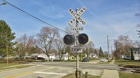
Active crossing:
https://www.google.com/maps/@32.6043447 ... 312!8i6656
https://www.google.com/maps/@32.6043447 ... 312!8i6656
They/Them for me, please.
Click here if you want to submit crossing photos to the site!
Avatar by runesprite on Twitter.
Click here if you want to submit crossing photos to the site!
Avatar by runesprite on Twitter.