Google Maps Scavenger Hunt (Traffic signals and signs)

Talk about other non-signal stuff here. Make sure to obey the rules though.

Moderators: freebrickproductions, mlgillson, TommyBNSF, Raco_GS

User avatar
NathanFromEngland
Posts: 2370
Joined: Sat Apr 29, 2017 3:52 pm
Location: Merseyside

Re: Google Maps Scavenger Hunt (Traffic signals and signs)

Post by NathanFromEngland » Sat May 06, 2017 4:51 pm

Some junctions (And two pedestrian crossings) a mile away from my house in Merseyside are being upgraded due to some roadworks that are mean't to last until the end of June 2017. Here are pictures of the old junction prior to their refurbishments.

All new signals will have Siemens LED Helios heads and Siemens LED Push Buttons.
Here is an example of what the typical junctions would include.

https://www.google.com/maps/@53.4917946 ... 6656?hl=en


https://www.google.com/maps/@53.4551059 ... 6656?hl=en
The signals were only just ripped out at least almost a month ago, The islands have been resurfaced, but no signs of signals anytime soon.

https://www.google.com/maps/@53.4538323 ... 6656?hl=en
These signals were turned off when excavators and diggers had to pull up water pipes which ripped out the signals on the middle, leaving just the two signals on the side. New signals were placed a few months ago and activated.

https://www.google.com/maps/@53.453265, ... 6656?hl=en
I was shocked to find these signals replaced, they were only four years old. They replaced the same style of pedestrian crossing like the one above.

https://www.google.com/maps/@53.4523737 ... 6656?hl=en
This junction was only completed a few weeks ago, new signals are in their place already.

https://www.google.com/maps/@53.4502504 ... 6656?hl=en
This junction is starting to reach final stages of completion, Half of the traffic signals are already installed but not activated until Siemens Traffic Solutions get all the signals installed and the wiring to the brand new control box.

For those wondering what the Siemens LED Pushbutton is, here is an image from Siemens website.

Image


When Google Street View finally gets new images of the new junctions (Sometime in a few months) i'll edit the posts.
Refer to me as 'Nari' - She/They are my preferred pronouns
User avatar
NathanFromEngland
Posts: 2370
Joined: Sat Apr 29, 2017 3:52 pm
Location: Merseyside

Re: Google Maps Scavenger Hunt (Traffic signals and signs)

Post by NathanFromEngland » Sun May 07, 2017 1:34 pm

Was looking up at Rhodes in Greece and saw this.

These lights haven't had a green light for some time!

https://www.google.com/maps/@36.4230899 ... 6656?hl=en
Approach to the signals.

https://www.google.com/maps/@36.4222015 ... 6656?hl=en
The junction, you can't turn left here as there is no central reservation! It looks as if they were going to install traffic lights here but i guess the 2009 Greek Economic Crisis put the plans on hold.
Refer to me as 'Nari' - She/They are my preferred pronouns
User avatar
NathanFromEngland
Posts: 2370
Joined: Sat Apr 29, 2017 3:52 pm
Location: Merseyside

Re: Google Maps Scavenger Hunt (Traffic signals and signs)

Post by NathanFromEngland » Mon May 08, 2017 10:46 am

Oh, and one more thing, why aren't i editing these posts altogether?

Merseyside has some daft looking signals.

This pelican crossing in Fazakerley has six lights with two on an extended bracket for some strange reason.
https://www.google.co.uk/maps/@53.46642 ... 6656?hl=en

At this junction near ASDA Aintree, this filter arrow may look LED to you, but its an unknown make of a Fibre-optic arrow.
https://www.google.co.uk/maps/@53.48898 ... 6656?hl=en

At the Great Yarmouth Haven Bridge, these arrows look to be PAGE Signals FIbre-Optic arrows, I think these are Generation 1 arrows.
https://www.google.co.uk/maps/@52.60697 ... 312!8i6656

Came across this September 2014 street view that looks to have been taken at dusk.
https://www.google.co.uk/maps/@53.48849 ... 6656?hl=en

Caught these lights in mid flash!
https://www.google.co.uk/maps/@53.49610 ... 6656?hl=en

Some poles look wider than the other ones.
https://www.google.co.uk/maps/@53.49739 ... 6656?hl=en

This junction has a combination of PEEK LED Traffic Lights along with PEEK LED Pushbuttons and an unknown make of LED Puffin Crossing pushbuttons. This junction was upgraded in 2012 due to the fire station being built where the junction is.
Here is the junction in 2009
https://www.google.co.uk/maps/@53.48998 ... 6656?hl=en
Here is the junction in 2014
https://www.google.co.uk/maps/@53.49046 ... 6656?hl=en

Could you spot what was happening in the 2009 image?

And finally, this pelican crossing has been through a ton of changes.
October 2009
https://www.google.co.uk/maps/@53.48968 ... 6656?hl=en
August 2016
https://www.google.co.uk/maps/@53.48971 ... 6656?hl=en
Refer to me as 'Nari' - She/They are my preferred pronouns
User avatar
McK&H.Aust
Posts: 926
Joined: Tue Feb 16, 2016 8:16 am
Location: Sydney, Australia

Re: Google Maps Scavenger Hunt (Traffic signals and signs)

Post by McK&H.Aust » Sun Jun 11, 2017 7:44 am

Not sure what's happened in other parts of the world, but in Australia many of the signs have been changed from wording to having symbols. The signs for pedestrian crossings had the word "Crossing" written above the symbol of a pair of legs, while the newer version has the wording removed. The older worded signs are now rare, however I discovered one today https://www.google.com.au/maps/@-34.484 ... 312!8i6656

the other side has the newer version https://www.google.com.au/maps/@-34.484 ... 312!8i6656

I was wondering if this practice is common elsewhere, and if people could share some worded signs which are becoming rare.
User avatar
freebrickproductions
Posts: 8532
Joined: Thu Jun 07, 2012 11:12 am
Location: Huntsville, AL
Contact:

Re: Google Maps Scavenger Hunt (Traffic signals and signs)

Post by freebrickproductions » Sun Jun 11, 2017 10:22 am

The US and Canada are both moving towards symbolic signage, though the latter has been doing it longer than the former.

However, there have been plenty of signs that were worded but changed to symbols in the US MUTCD over the past few years, such as the Stop Ahead sign. Here's an old worded one in Limestone County that was recently replaced:
https://www.google.com/maps/@34.9646295 ... 312!8i6656

However, even rarer here is the old Stop Ahead assemblies that still feature the old ALDOT practice of using an "Intersection" banner above the sign and sometime listing a distance below the sign, such as this remaining one in Killen, AL:
ImageOld Stop Ahead Signage Assembly by freebrickproductions, on Flickr

I've also managed to stumble across a few worded Pedestrian Crossing signs, such as this pair in Ardmore, AL:
https://www.google.com/maps/@34.9910884 ... 312!8i6656
https://www.google.com/maps/@34.9906736 ... 312!8i6656

And then you have the worded "School Bus Stop Ahead" signs, which appear to have become rather rare (at least in my area) as they were replaced in the MUTCD with symbolic ones sometime within the past 10 years. Here's a pair that were replaced on US 231 in Lacey's Springs, AL:
https://www.google.com/maps/@34.5445542 ... 312!8i6656
The replacement signage:
https://www.google.com/maps/@34.5446211 ... 312!8i6656

And then you also have the worded pedestrian signals, which got removed in the 2003 MUTCD, that are steadily being replaced with symbolic ones, such as this one that's still there in Athens, AL:
https://www.google.com/maps/@34.8022625 ... 312!8i6656

However, in a bit of a weird case, the symbolic Narrow Bridge signs are rather rare here, as they got removed from the MUTCD after they were introduced (reverting the standard design back to the worded ones) due to confusing too many drivers on the road. For example, here's one that's still in service along AL 35:
ImageNarrow Bridge by freebrickproductions, on Flickr
They/Them for me, please.

Click here if you want to submit crossing photos to the site!

Avatar by runesprite on Twitter.
User avatar
ToledoRailfan
No Longer Associated With The Forum
Posts: 3315
Joined: Sun Jul 21, 2013 2:38 pm

Re: Google Maps Scavenger Hunt (Traffic signals and signs)

Post by ToledoRailfan » Sun Jun 11, 2017 2:02 pm

freebrickproductions wrote: And then you have the worded "School Bus Stop Ahead" signs, which appear to have become rather rare (at least in my area) as they were replaced in the MUTCD with symbolic ones sometime within the past 10 years. Here's a pair that were replaced on US 231 in Lacey's Springs, AL:
https://www.google.com/maps/@34.5445542 ... 312!8i6656
The replacement signage:
https://www.google.com/maps/@34.5446211 ... 312!8i6656
I don't think I've ever seen any school bus stop signs ever.
freebrickproductions wrote: However, in a bit of a weird case, the symbolic Narrow Bridge signs are rather rare here, as they got removed from the MUTCD after they were introduced (reverting the standard design back to the worded ones) due to confusing too many drivers on the road. For example, here's one that's still in service along AL 35:
ImageNarrow Bridge by freebrickproductions, on Flickr
I wouldn't know what it means. It is kind of a good thing that they got rid of that one.
User avatar
NathanFromEngland
Posts: 2370
Joined: Sat Apr 29, 2017 3:52 pm
Location: Merseyside

Re: Google Maps Scavenger Hunt (Traffic signals and signs)

Post by NathanFromEngland » Sun Jun 11, 2017 2:22 pm

Refer to me as 'Nari' - She/They are my preferred pronouns
User avatar
ToledoRailfan
No Longer Associated With The Forum
Posts: 3315
Joined: Sun Jul 21, 2013 2:38 pm

Re: Google Maps Scavenger Hunt (Traffic signals and signs)

Post by ToledoRailfan » Sun Jun 11, 2017 2:40 pm

NathanFromEngland wrote:A bunch of signs joined together.
https://www.google.co.uk/maps/@53.48155 ... 312!8i6656
What the hell?! Who thought that was a good idea!? :Blink: :Confused:
User avatar
TrickyMario7654
Posts: 1355
Joined: Fri Aug 26, 2016 6:45 pm
Location: Melbourne, Australia

Re: Google Maps Scavenger Hunt (Traffic signals and signs)

Post by TrickyMario7654 » Sun Jun 11, 2017 6:05 pm

Here's some old National Route 1 markers/signs I've noticed along the old route of the Princes Highway and nearby roads.

This one near the intersection of Toomuc Valley Road & Princes Highway in Pakenham still remains (as I drove by it two days ago)
https://www.google.com.au/maps/@-38.063 ... 312!8i6656

Just further down the road, is this newer (but outdated) direction signs for the M1. This section of the highway was renumbered C101 following the opening of the Pakenham bypass (which received the M1 number). It notes Melbourne to the right, and Warragul to the left...
https://www.google.com.au/maps/@-38.063 ... 312!8i6656

But as with most direction signs along the old highway route, the Warragul-bound sign was changed to Pakenham, and the Melbourne-bound sign was changed to Berwick.
https://www.google.com.au/maps/@-38.064 ... 312!8i6656

Here's what the Berwick direction sign used to say...
https://www.google.com.au/maps/@-38.064 ... 328!8i1664

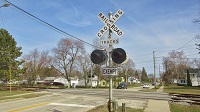
Here's two I've noticed in Officer last year while getting the crossings in the area...

The first one is on a directions sign located at Station Street, shortly before the Princess Highway intersection.
https://www.google.com.au/maps/@-38.060 ... 312!8i6656

Another one at Brunt Road, again, shortly before the Princes Highway intersection.
https://www.google.com.au/maps/@-38.056 ... 312!8i6656

An old State Route 180 shield on a direction sign at the South Gippsland Highway intersection of the Princes Highway in Dandenong South. The State Route shields replaced with A, B, & C routes in the late 1990's, so I don't know how this one still remains.
https://www.google.com.au/maps/@-38.000 ... 312!8i6656

There used to be a END 180 sign on the other side of the road, but it was removed sometime after 2010. (I do remember driving by it at some point before it was removed)
https://www.google.com.au/maps/@-38.001 ... 312!8i6656

I found this outdated Metropolitan Route 63 shield at Webb Street in Narre Warren.
https://www.google.com.au/maps/@-38.024 ... 312!8i6656

Not only has Route 63 been redirected onto a diversion of Narre Warren North Road, but it was replaced with C404 in the late 1990's!

Before the early 1990's, Webb Street used to connect to Narre Warren North Road, with traffic having to turn left onto Princes Highway from Webb Street, before turning right onto Cranbourne Road. The 1990 edition shows the old route, with the future route showed in dotted, transparent lines.
https://digitised-collections.unimelb.e ... quence=142

The 1991 edition shows the link under construction.
https://digitised-collections.unimelb.e ... quence=142

By the time the 1993 edition came out, the link had been finished and the route 63 shield was moved onto the new road link. Webb Street was also closed at where it used to connect to Narre Warren North Road.
https://digitised-collections.unimelb.e ... quence=150

By the late 1990's, the reroute had proven to be a good idea as the road had been duplicated up to where the highway was and merged down to one lane in each direction by the time you reached where the level crossing on Cranbourne Road.
https://digitised-collections.unimelb.e ... quence=156

In 2004, the road was further upgraded, with the level crossing replaced with an underpass.
https://www.google.com.au/maps/@-38.028 ... 312!8i6656

Here's some pictures I've found of the former level crossing on Railpage, taken back in 2002.
https://www.railpage.com.au/gallery?image=28240
https://www.railpage.com.au/gallery?image=28198
https://www.railpage.com.au/gallery?image=28197
https://www.railpage.com.au/gallery?image=28147
User avatar
McK&H.Aust
Posts: 926
Joined: Tue Feb 16, 2016 8:16 am
Location: Sydney, Australia

Re: Google Maps Scavenger Hunt (Traffic signals and signs)

Post by McK&H.Aust » Sun Jun 11, 2017 6:51 pm

freebrickproductions wrote:However, even rarer here is the old Stop Ahead assemblies that still feature the old ALDOT practice of using an "Intersection" banner above the sign and sometime listing a distance below the sign, such as this remaining one in Killen, AL:
ImageOld Stop Ahead Signage Assembly by freebrickproductions, on Flickr
Great pictures, the sign post looks to be made from cement. You've reminded me how it's not just the signs themselves, but also the posts which have changed. There used to be some cement sign posts in Australia, along with wooden ones, but now they are nearly all aluminium or steel. Those signs over here were worded "Stop Sign Ahead" but now this symbol is used instead https://www.google.com.au/maps/@-31.406 ... 312!8i6656


freebrickproductions wrote:However, in a bit of a weird case, the symbolic Narrow Bridge signs are rather rare here, as they got removed from the MUTCD after they were introduced (reverting the standard design back to the worded ones) due to confusing too many drivers on the road. For example, here's one that's still in service along AL 35:
ImageNarrow Bridge by freebrickproductions, on Flickr
Over here they have persisted with the narrow bridge symbols such as this https://www.google.com.au/maps/@-30.667 ... 312!8i6656

There are still a few worded signs surviving, I think this one could not be replaced by symbols! https://www.google.com.au/maps/@-34.629 ... 312!8i6656
Post Reply