
HAZARDOUS WEATHER OUTLOOK...UPDATE
NATIONAL WEATHER SERVICE MILWAUKEE/SULLIVAN WI
954 PM CDT SAT APR 9 2011
WIZ046-047-051-052-056>060-062>072-102100-
MARQUETTE-GREEN LAKE-FOND DU LAC-SHEBOYGAN-SAUK-COLUMBIA-DODGE-
WASHINGTON-OZAUKEE-IOWA-DANE-JEFFERSON-WAUKESHA-MILWAUKEE-
LAFAYETTE-GREEN-ROCK-WALWORTH-RACINE-KENOSHA-
954 PM CDT SAT APR 9 2011
THIS HAZARDOUS WEATHER OUTLOOK IS FOR PORTIONS OF EAST CENTRAL
WISCONSIN...SOUTH CENTRAL WISCONSIN AND SOUTHEAST WISCONSIN.
.DAY ONE...TONIGHT
THUNDERSTORMS OVER THE STATE OF IOWA WILL MOVE NORTHEAST INTO
CENTRAL WISCONSIN DURING THE OVERNIGHT. THUS THE MAJORITY OF THE
THUNDERSTORMS WILL REMAIN NORTH OF MADISON AND MILWAUKEE. THERE IS A
SLIGHT RISK THAT THESE THUNDERSTORMS WILL BECOME SEVERE WITH LARGE
HAIL.
PATCHY TO DENSE FOG WILL CONTINUE NEAR LAKE MICHIGAN TONIGHT AS A
MOIST AIRMASS FLOWS OVER THE COLD WATERS OF LAKE MICHIGAN.
.DAYS TWO THROUGH SEVEN...SUNDAY THROUGH SATURDAY
THERE IS A MODERATE RISK FOR SEVERE THUNDERSTORMS OVER SOUTH
CENTRAL AND SOUTHEAST WISCONSIN SUNDAY AFTERNOON INTO SUNDAY
NIGHT...AS STRONG LOW PRESSURE MOVES NORTHEAST THROUGH THE UPPER
MISSISSIPPI RIVER VALLEY...DRAGGING A STRONG COLD FRONT THROUGH
SOUTHERN WISCONSIN.
THE STRENGTH OF THIS WEATHER SYSTEM...INSTABILITY AND WIND
SHEAR...COULD PRODUCE WIDESPREAD DAMAGING WINDS...LARGER THAN GOLF
BALL SIZE HAIL...AND STRONG TORNADOES.
ANYONE WITH PLANS ACROSS THE REGION SUNDAY AFTERNOON AND EVENING
WILL NEED TO MONITOR THE SEVERE WEATHER SITUATION CLOSELY.
.SPOTTER INFORMATION STATEMENT...
SPOTTER ACTIVATION MAY BE NEEDED DURING THE OVERNIGHT AND WILL BE
NEEDED SUNDAY AFTERNOON AND EVENING.
Tornado season 2011 - It Begins
Moderators: freebrickproductions, mlgillson, TommyBNSF, Raco_GS
Tornado season 2011 - It Begins
http://www.spc.noaa.gov/products/outlook/day2otlk.html
Badgerland Rail Videos: https://www.youtube.com/@BadgerlandRailVideos
Rail photos: http://andyws.rrpicturearchives.net
Rail photos: http://andyws.rrpicturearchives.net
-
TrainmanKight

- Site Admin
- Posts: 1373
- Joined: Fri Jan 30, 2009 11:17 pm
- Location: St Louis, Mo and every where else under the sun.
- Contact:
Re: Tornado season 2011 - It Begins
Double posted so I got rid of the other one
YAH we had some really crazy lightning storms the other day wind got bad too
YAH we had some really crazy lightning storms the other day wind got bad too
They who can give up essential liberty to obtain a little temporary safety, deserve neither liberty nor safety. Ben Franklin
People who need a foot up their Ass affect the lives of many. There is still no cure for someone who needs a foot up their Ass, except a foot up their Ass
I speak my mind, if you don't like that oh well. I'll have you fill out a hurt feelings report and submit that to my office.
Be Sure To See My YouTube Account http://www.youtube.com/user/TrainmanKight

Re: Tornado season 2011 - It Begins
In rainy Houston, TX, we have not gotten a drop of rain ever since February.
+:No 100% humidity
-:No fireworks on the 4th of July.
+:No 100% humidity
-:No fireworks on the 4th of July.
Rob
Certrified BNSF Lover.
BNSF rulez!
Certrified BNSF Lover.
BNSF rulez!

Re: Tornado season 2011 - It Begins
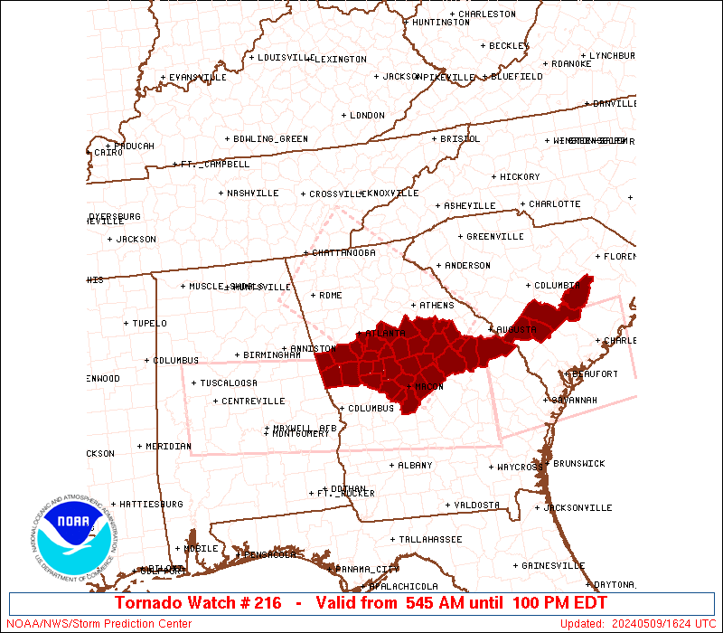
Here's what's going on in my area this afternoon... A "P.D.S." (Particularly Dangerous Situation) Tornado Watch:
http://www.spc.noaa.gov/products/watch/ww0215.html
...THIS IS A PARTICULARLY DANGEROUS SITUATION...
DESTRUCTIVE TORNADOES...LARGE HAIL TO 4 INCHES IN DIAMETER...
THUNDERSTORM WIND GUSTS TO 80 MPH...AND DANGEROUS LIGHTNING ARE
POSSIBLE IN THESE AREAS
High probability of Tornadoes stronger than EF-2
High probaility of severe thunderstorm wind gusts over 65 knots
High probability of hail over 2" in diameter
Gotta love springtime in North Texas!
-
MichiganCSX622
- Posts: 62
- Joined: Tue Feb 10, 2009 7:45 pm
Re: Tornado season 2011 - It Begins
New tornado watch issued for my area in SE Michigan
Re: Tornado season 2011 - It Begins
...and its been a bad one so far. Wisconsin did indeed have its largest tornado outbreak ever recorded for the state in the month of April on the 10th (there have been worse ones in other months), with 14 tornadoes, one of them rated EF3 and three rated EF2.
The outbreak was concentrated in the northern part of the state, very rare for that early in the spring. That came on the heels of the EF3 Mapleton, Iowa tornado on the evening of the 9th.
Several destructive, and in some cases killer, EF3 tornadoes hit towns from Oklahoma to Mississippi/Alabama to North Carolina on April 14th through the 16th.
The Enhanced Fujita scale ratings are a little bit deceptive because an EF3 tornado is devastating to ordinary houses, by the time you get to EF4 and EF5 it's just a matter of how far the debris is blown (and they will start to destroy stronger buildings as well).
On the 19th, several strong tornadoes affected eastern Missouri and west-central Illinois, north of the St. Louis metropolitan area.
Then on the 22nd, an EF4 tornado tracked right through St. Louis doing massive amounts of damage. Miraculously no one was killed.
The current outbreak began in Arkansas on Monday, with a tornado of at least EF2 strength killing four people at Vilonia. Strong tornadoes took place from Texas to Tennessee last night, and again this afternoon with major damage, deaths and injuries in northern Mississippi and Alabama (the worst of the outbreak on the 15th was concentrated in the southern portions of those states, close to the Gulf Coast).
http://www.cbs42.com/mostpopular/story/ ... TFy6A.cspx

http://en.wikipedia.org/wiki/Tornadoes_of_2011
The outbreak was concentrated in the northern part of the state, very rare for that early in the spring. That came on the heels of the EF3 Mapleton, Iowa tornado on the evening of the 9th.
Several destructive, and in some cases killer, EF3 tornadoes hit towns from Oklahoma to Mississippi/Alabama to North Carolina on April 14th through the 16th.
The Enhanced Fujita scale ratings are a little bit deceptive because an EF3 tornado is devastating to ordinary houses, by the time you get to EF4 and EF5 it's just a matter of how far the debris is blown (and they will start to destroy stronger buildings as well).
On the 19th, several strong tornadoes affected eastern Missouri and west-central Illinois, north of the St. Louis metropolitan area.
Then on the 22nd, an EF4 tornado tracked right through St. Louis doing massive amounts of damage. Miraculously no one was killed.
The current outbreak began in Arkansas on Monday, with a tornado of at least EF2 strength killing four people at Vilonia. Strong tornadoes took place from Texas to Tennessee last night, and again this afternoon with major damage, deaths and injuries in northern Mississippi and Alabama (the worst of the outbreak on the 15th was concentrated in the southern portions of those states, close to the Gulf Coast).
http://www.cbs42.com/mostpopular/story/ ... TFy6A.cspx
http://en.wikipedia.org/wiki/Tornadoes_of_2011
Badgerland Rail Videos: https://www.youtube.com/@BadgerlandRailVideos
Rail photos: http://andyws.rrpicturearchives.net
Rail photos: http://andyws.rrpicturearchives.net
Re: Tornado season 2011 - It Begins
Think about the scene at the St. Louis Airport right after that tornado blew through.
Rob
Certrified BNSF Lover.
BNSF rulez!
Certrified BNSF Lover.
BNSF rulez!
-
weatherdan882002

- Posts: 544
- Joined: Sat Feb 07, 2009 8:45 pm
- Location: Mechanicville, NY
- Contact:
Re: Tornado season 2011 - It Begins
Of course, it's hard to miss the coverage about what happened last night.
We had some tornadoes in NYS, one happened not too far from me and has been confirmed by the NWS to have been an EF1. By the time they got to where I am though, they were just thunder and downpours.
We had some tornadoes in NYS, one happened not too far from me and has been confirmed by the NWS to have been an EF1. By the time they got to where I am though, they were just thunder and downpours.

Re: Tornado season 2011 - It Begins
If this season has just begun... I'm sure hoping the worst has already happened.
Some incredible footage of the Tuscaloosa EF4. This guy ended up being about a block away from it and one point, then drove into the path where the tornado just hit. Got some b lls to be that close to such a massive tornado.
Just a warning, dude was obviously a little freaked out so the camera is quite shaky at times. He also says the s-word towards the end.
Some incredible footage of the Tuscaloosa EF4. This guy ended up being about a block away from it and one point, then drove into the path where the tornado just hit. Got some b
Just a warning, dude was obviously a little freaked out so the camera is quite shaky at times. He also says the s-word towards the end.

Re: Tornado season 2011 - It Begins
This storm looks like it's heading straight for me.
SEVERE WEATHER STATEMENT
NATIONAL WEATHER SERVICE LINCOLN IL
630 PM CDT WED MAY 25 2011
ILC113-260000-
/O.CON.KILX.TO.W.0038.000000T0000Z-110526T0000Z/
MCLEAN IL-
630 PM CDT WED MAY 25 2011
...A TORNADO WARNING REMAINS IN EFFECT FOR EASTERN MCLEAN COUNTY
UNTIL 700 PM CDT...
AT 628 PM CDT...NATIONAL WEATHER SERVICE METEOROLOGISTS DETECTED A
SEVERE THUNDERSTORM CAPABLE OF PRODUCING A TORNADO. THIS DANGEROUS
STORM WAS LOCATED NEAR LEXINGTON...OR 15 MILES NORTHEAST OF
BLOOMINGTON...MOVING NORTH AT 60 MPH.
LOCATIONS IMPACTED INCLUDE...
CHENOA AND WESTON.
PRECAUTIONARY/PREPAREDNESS ACTIONS...
TAKE COVER NOW. MOVE TO AN INTERIOR ROOM ON THE LOWEST FLOOR OF A
STURDY BUILDING. AVOID WINDOWS. IF IN A MOBILE HOME...A VEHICLE OR
OUTDOORS...MOVE TO THE CLOSEST SUBSTANTIAL SHELTER AND PROTECT
YOURSELF FROM FLYING DEBRIS.
&&
LAT...LON 4062 8857 4062 8850 4061 8850 4028 8878
4028 8888 4034 8901 4052 8885 4075 8878
4076 8858
TIME...MOT...LOC 2331Z 197DEG 54KT 4065 8873
$$
BARKER