Forget if this was posted, but here's an abandoned B&O line in Uhrichsville, OH:
https://www.google.com/maps/@40.3905428 ... 312!8i6656
https://www.google.com/maps/@40.3856675 ... 312!8i6656
Tracks out of service
Moderators: freebrickproductions, mlgillson, PlyingKibbles89, Raco_GS, Hopen111, TommyBNSF
-
freebrickproductions

- Posts: 9305
- kuchnie-na-wymiar.wroclaw.pl
- Joined: Thu Jun 07, 2012 11:12 am
- Location: Huntsville, AL
- Contact:
Re: Tracks out of service
They/Them for me, please.
Click here if you want to submit crossing photos to the site!
Avatar by runesprite on Twitter.
Click here if you want to submit crossing photos to the site!
Avatar by runesprite on Twitter.

Re: Tracks out of service
That's quite an interesting mix of Griswold and US&S equipment there!freebrickproductions wrote:Forget if this was posted, but here's an abandoned B&O line in Uhrichsville, OH:
https://www.google.com/maps/@40.3905428 ... 312!8i6656
Also:
https://www.google.com/maps/@40.3906462 ... 312!8i6656
Wishbone pedestrian gate
Crossing pictures from Plant City, FL are finally here! viewtopic.php?f=13&t=2538
-
freebrickproductions
- Posts: 9305
- Joined: Thu Jun 07, 2012 11:12 am
- Location: Huntsville, AL
- Contact:
Re: Tracks out of service
Based on this guy's photo, the "US&S" equipment appears to be GRS:ZachL wrote:That's quite an interesting mix of Griswold and US&S equipment there!freebrickproductions wrote:Forget if this was posted, but here's an abandoned B&O line in Uhrichsville, OH:
https://www.google.com/maps/@40.3905428 ... 312!8i6656
Also:
https://www.google.com/maps/@40.3906462 ... 312!8i6656
Wishbone pedestrian gate
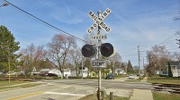
 B&O Grade Crossing Signal - Uhrichsville Ohio by Raymond D. Woods, Jr., on Flickr
I do agree on the Wishbone ped get though, that thing is just cool.
Also, EM pedestrian signals just look weird:
https://www.google.com/maps/@40.3907104 ... 312!8i6656
https://www.google.com/maps/@40.390582, ... 312!8i6656
They/Them for me, please.
Click here if you want to submit crossing photos to the site!
Avatar by runesprite on Twitter.
Click here if you want to submit crossing photos to the site!
Avatar by runesprite on Twitter.
Re: Tracks out of service
Wow, today I learned that GRS made cantilevers in that style. I honestly only thought those were made by Griswold and US&S!
Crossing pictures from Plant City, FL are finally here! viewtopic.php?f=13&t=2538
-
freebrickproductions
- Posts: 9305
- Joined: Thu Jun 07, 2012 11:12 am
- Location: Huntsville, AL
- Contact:
Re: Tracks out of service
The old cantilevers at 2nd Street in Birmingham were GRS as well. These have also been found with "Peerless Manufacturing Corp" and WRRS brandings on them.ZachL wrote:Wow, today I learned that GRS made cantilevers in that style. I honestly only thought those were made by Griswold and US&S!
http://www.rxrsignals.com/Alabama/Birmingham/2/
They/Them for me, please.
Click here if you want to submit crossing photos to the site!
Avatar by runesprite on Twitter.
Click here if you want to submit crossing photos to the site!
Avatar by runesprite on Twitter.

Re: Tracks out of service
I thought this was interesting... https://www.google.com/maps/@40.3856675 ... 312!8i6656freebrickproductions wrote: https://www.google.com/maps/@40.3856675 ... 312!8i6656
Looks like a standard household light bulb in there.
-
ToledoRailfan
- No Longer Associated With The Forum
- Posts: 3315
- Joined: Sun Jul 21, 2013 2:38 pm
Re: Tracks out of service
That is defiantly very strange, I wonder if it was used as a cab signal to notify the crew that the crossing is working properly?cabman701 wrote:I thought this was interesting... https://www.google.com/maps/@40.3856675 ... 312!8i6656freebrickproductions wrote: https://www.google.com/maps/@40.3856675 ... 312!8i6656
Looks like a standard household light bulb in there.
Re: Tracks out of service
Hmm, this is an interesting display with the telegraph wires hanging low:
https://www.google.com/maps/@40.385623, ... 312!8i6656
https://www.google.com/maps/@40.385623, ... 312!8i6656
Crossing pictures from Plant City, FL are finally here! viewtopic.php?f=13&t=2538
-
freebrickproductions
- Posts: 9305
- Joined: Thu Jun 07, 2012 11:12 am
- Location: Huntsville, AL
- Contact:
Re: Tracks out of service
Found this line in Georgia. Appears to be an ex-NS/SOU branch line, and is now under the ownership of a shortline. Doesn't appear to get any use though, tracks look to have been removed at a bridge between the first crossing and the "mainline" of the short line:
https://www.google.com/maps/@33.40801,- ... 312!8i6656
https://www.google.com/maps/@33.4121513 ... 312!8i6656
https://www.google.com/maps/@33.4375937 ... 312!8i6656
https://www.google.com/maps/@33.442907, ... 312!8i6656
https://www.google.com/maps/@33.4627988 ... 312!8i6656
https://www.google.com/maps/@33.4801295 ... 312!8i6656
Interestingly enough, there are a bunch of hoppers stored on this line in Newborn, GA. Not sure why, and they appear to have been there for a while, so I have no idea if they were put there years ago and just forgotten about:
https://www.google.com/maps/@33.4878088 ... 312!8i6656
Not sure if they're still there. Looks like they've been removed on satellite view.
Railroad ƃuᴉssoɹƆ and a hopper:
https://www.google.com/maps/@33.4960652 ... 312!8i6656
https://www.google.com/maps/@33.5052746 ... 312!8i6656
North end of the hoppers:
https://www.google.com/maps/@33.5052945 ... 312!8i6656
https://www.google.com/maps/@33.5092706 ... 312!8i6656
The line is definitely out of service from this point on:
https://www.google.com/maps/@33.5161984 ... 312!8i6656
https://www.google.com/maps/@33.5168302 ... 312!8i6656
Here's how this crossing looked when it was still in use back in 2009:
https://www.google.com/maps/@33.5168625 ... 328!8i1664
https://www.google.com/maps/@33.5180085 ... 312!8i6656
https://www.google.com/maps/@33.5180207 ... 312!8i6656
Back in 2008 when the crossing still had signals, one of which was 8 inch and the other was 12x24 inch with what appears to be a WCH mechanical bell:
https://www.google.com/maps/@33.5180238 ... 328!8i1664
Another Railroad ƃuᴉssoɹƆ.
https://www.google.com/maps/@33.520269, ... 312!8i6656
Another pair of 8 inch signals! Not sure if they're still there though.
https://www.google.com/maps/@33.5181196 ... 312!8i6656
https://www.google.com/maps/@33.5177581 ... 312!8i6656
https://www.google.com/maps/@33.5168506 ... 312!8i6656
Four crossbucks here in this 2007 imagery, wonder how many are left?
https://www.google.com/maps/@33.5232148 ... 328!8i1664
Not much left of the line here on this dirt road other than this crossbuck post:
https://www.google.com/maps/@33.5243517 ... 312!8i6656
And these "No Trespassing; Property of Norfolk Southern" sign:
https://www.google.com/maps/@33.5243115 ... 312!8i6656
https://www.google.com/maps/@33.5243115 ... 312!8i6656
I wonder what NS plans on doing with the ROW, now that they've torn out the tracks. Do they even care if one were to walk along it?
https://www.google.com/maps/@33.53949,- ... 312!8i6656
The tracks are still here in this 2013 imagery, but are gone in the above 2015 imagery. Rails must've been torn out sometime between 2013 and 2015:
https://www.google.com/maps/@33.5570867 ... 312!8i6656
https://www.google.com/maps/@33.5604896 ... 312!8i6656
https://www.google.com/maps/@33.5744066 ... 312!8i6656
Going back to 2013 shows it with the tracks:
https://www.google.com/maps/@33.5743934 ... 312!8i6656
And 2008 shows crossbucks:
https://www.google.com/maps/@33.5744085 ... 328!8i1664
https://www.google.com/maps/@33.5936394 ... 312!8i6656
Not much left here now:
https://www.google.com/maps/@33.5944414 ... 312!8i6656
2013:
https://www.google.com/maps/@33.5944325 ... 312!8i6656
2008:
https://www.google.com/maps/@33.5943334 ... 328!8i1664
Same for the next crossing over:
https://www.google.com/maps/@33.5949736 ... 312!8i6656
2013:
https://www.google.com/maps/@33.5950005 ... 312!8i6656
2008:
https://www.google.com/maps/@33.5949912 ... 328!8i1664
They left a bit of the partially wood and partially asphalt here!
https://www.google.com/maps/@33.5960681 ... 312!8i6656
https://www.google.com/maps/@33.5963403 ... 312!8i6656
2013:
https://www.google.com/maps/@33.5961811 ... 312!8i6656
https://www.google.com/maps/@33.596307, ... 312!8i6656
2008:
https://www.google.com/maps/@33.5959013 ... 328!8i1664
2007:
https://www.google.com/maps/@33.5963227 ... 328!8i1664
https://www.google.com/maps/@33.5967416 ... 312!8i6656
https://www.google.com/maps/@33.5979745 ... 312!8i6656
One of the crossbucks had already been turned away from the road back in 2008:
https://www.google.com/maps/@33.5980227 ... 328!8i1664
https://www.google.com/maps/@33.598516, ... 312!8i6656
2016:
https://www.google.com/maps/@33.5985389 ... 312!8i6656
2013:
https://www.google.com/maps/@33.5985389 ... 312!8i6656
2007:
https://www.google.com/maps/@33.5985221 ... 328!8i1664
https://www.google.com/maps/@33.5988225 ... 312!8i6656
They left behind a relay case here!
https://www.google.com/maps/@33.6013076 ... 312!8i6656
The crossing appears to have had a pair of WRRS 8 inch signals originally:
https://www.google.com/maps/@33.6012107 ... 328!8i1664
https://www.google.com/maps/@33.6014874 ... 328!8i1664
https://www.google.com/maps/@33.601855, ... 312!8i6656
https://www.google.com/maps/@33.6028766 ... 312!8i6656
The line splits after that. One track leads towards a CSX line, and the other curves back south.
Track that leads towards a CSX line:
https://www.google.com/maps/@33.6040618 ... 312!8i6656
https://www.google.com/maps/@33.6056183 ... 312!8i6656
Track that curves back south:
https://www.google.com/maps/@33.60365,- ... 312!8i6656
https://www.google.com/maps/@33.5986301 ... 312!8i6656
The tracks did go through the area between the street view car and the gate:
https://www.google.com/maps/@33.593601, ... 312!8i6656
https://www.google.com/maps/@33.5908254 ... 312!8i6656
https://www.google.com/maps/@33.5887212 ... 312!8i6656
A little bit of the tracks remains here, interestingly enough:
https://www.google.com/maps/@33.5822985 ... 312!8i6656
https://www.google.com/maps/@33.5820856 ... 312!8i6656
The tracks disappear after that.
They/Them for me, please.
Click here if you want to submit crossing photos to the site!
Avatar by runesprite on Twitter.
Click here if you want to submit crossing photos to the site!
Avatar by runesprite on Twitter.
-
ToledoRailfan
- No Longer Associated With The Forum
- Posts: 3315
- Joined: Sun Jul 21, 2013 2:38 pm
Re: Tracks out of service
Abandon crossings and tracks in Tczew, Pomeranian Voivodeship. https://www.google.com/maps/@54.094323, ... 6656?hl=en https://www.google.com/maps/@54.0944994 ... 6656?hl=en
https://www.google.com/maps/@54.0944994 ... 6656?hl=en
https://www.google.com/maps/@54.0946587 ... 6656?hl=en
https://www.google.com/maps/@54.0946587 ... 6656?hl=en
https://www.google.com/maps/@54.0950528 ... 6656?hl=en
--------------------------------------------
Abandon crossings in Pruszcz Gdański and Kolbudy, Pomeranian Voivodeship. https://www.google.com/maps/@54.2477715 ... 6656?hl=en https://www.google.com/maps/@54.2478326 ... 6656?hl=en
https://www.google.com/maps/@54.2478076 ... 6656?hl=en
https://www.google.com/maps/@54.2478076 ... 6656?hl=en
This one has new signals.
https://www.google.com/maps/@54.2466993 ... 6656?hl=en
https://www.google.com/maps/@54.2470766 ... 6656?hl=en
https://www.google.com/maps/@54.2469469 ... 6656?hl=en
https://www.google.com/maps/@54.2469469 ... 6656?hl=en
https://www.google.com/maps/@54.2472395 ... 6656?hl=en
https://www.google.com/maps/@54.2474529 ... 6656?hl=en
https://www.google.com/maps/@54.2542563 ... 6656?hl=en
https://www.google.com/maps/@54.2566133 ... 6656?hl=en
https://www.google.com/maps/@54.2696608 ... 6656?hl=en
https://www.google.com/maps/@54.2696608 ... 6656?hl=en
https://www.google.com/maps/@54.2696708 ... 6656?hl=en