Google Maps Scavenger Hunt

Talk about signals ranging from wigwags to EVA signals here.

Moderators: freebrickproductions, mlgillson, PlyingKibbles89, Raco_GS, Hopen111, TommyBNSF

User avatar
TrickyMario7654
Posts: 1360
kuchnie-na-wymiar.wroclaw.pl
Joined: Fri Aug 26, 2016 6:45 pm
Location: Melbourne, Australia

Re: Google Maps Scavenger Hunt

Post by TrickyMario7654 »

Here's a crossing in Melbourne which was replaced with an overpass by dropping the rail line into a trench (This one being Springvale Road, Nunawading).
Before (2008): https://www.google.com.au/maps/@-37.820 ... 328!8i1664
During (2009, I think it's active too!): https://www.google.com.au/maps/@-37.820 ... 312!8i6656
After (2010): https://www.google.com.au/maps/@-37.820 ... 312!8i6656

Another example at Springvale Road, Springvale. My rail line (The Pakenham one) passes through Springvale station.
Before (May 2013): https://www.google.com.au/maps/@-37.948 ... 312!8i6656
During (Oct 2013, notice how the gate layout has changed): https://www.google.com.au/maps/@-37.948 ... 312!8i6656
After (2015): https://www.google.com.au/maps/@-37.948 ... 312!8i6656
I've also got a video of the crossing in action before they removed it...


Temporary crossing used at Taylors Road during the construction of an underpass.
https://www.google.com.au/maps/@-37.727 ... 328!8i1664

Also found this crossing in which Streetview caught the gates rising after a train went through.
https://www.google.com.au/maps/@-37.829 ... 328!8i1664
It also had a black and white barrier until 2009-ish.
https://www.google.com.au/maps/@-37.829 ... 328!8i1664
The same crossing also had a Safetran Mechanical bell (Since replaced with an E-Bell).
https://www.google.com.au/maps/@-37.829 ... 312!8i6656

Another active crossing.
https://www.google.com.au/maps/@-37.886 ... 312!8i6656

Found a view more trains in Street View.

Found this X'trapolis train ran by Metro Trains going over Waterdale Road, Ivanhoe.
https://www.google.com.au/maps/@-37.770 ... 312!8i6656

A Comeng set at Carnegie station.
https://www.google.com.au/maps/@-37.886 ... 312!8i6656

DAH! I found the Devil's Comeng! Carriage 666M in the Dandenong stabling yard.
https://www.google.com.au/maps/@-37.987 ... 312!8i6656

Not train related, but I found this truck blocking a street.
https://www.google.com.au/maps/@-37.885 ... 328!8i1664
Google Streetview obviously went around the truck.
https://www.google.com.au/maps/@-37.885 ... 328!8i1664
Last edited by TrickyMario7654 on Sat Sep 24, 2016 5:21 am, edited 2 times in total.
User avatar
ToledoRailfan
No Longer Associated With The Forum
Posts: 3315
Joined: Sun Jul 21, 2013 2:38 pm

Re: Google Maps Scavenger Hunt

Post by ToledoRailfan »

TrickyMario7654 wrote:
Here's a crossing in Melbourne which was replaced with an overpass by dropping the rail line into a trench (This one being Springvale Road, Nunawading).
Before (2008): https://www.google.com.au/maps/@-37.820 ... 328!8i1664
During (2009, I think it's active too!): https://www.google.com.au/maps/@-37.820 ... 312!8i6656
After (2010): https://www.google.com.au/maps/@-37.820 ... 312!8i6656

Another example at Springvale Road, Springvale. My rail line (The Pakenham one) passes through Springvale station.
Before (May 2013): https://www.google.com.au/maps/@-37.948 ... 312!8i6656
During (Oct 2013, notice how the gate layout has changed): https://www.google.com.au/maps/@-37.948 ... 312!8i6656
After (2015): https://www.google.com.au/maps/@-37.948 ... 312!8i6656
I've also got a video of the crossing in action before they removed it...
Replacing crossings with overpasses and underpasses is not uncommon, the crossing that I mention had replaced an underpass.
User avatar
TrickyMario7654
Posts: 1360
Joined: Fri Aug 26, 2016 6:45 pm
Location: Melbourne, Australia

Re: Google Maps Scavenger Hunt

Post by TrickyMario7654 »

ToledoRailfan wrote:Replacing crossings with overpasses and underpasses is not uncommon, the crossing that I mention had replaced an underpass.
I know that, I was just giving examples.

Anyways, I've got more train finds to show off...

Found the Comeng carriage (392M) that derailed at Ringwood in 1992 by running into the now-gone siding and stopping on the baulks half way in the air at the edge of the Wantirna Rd bridge coupled up to the same set that hit a truck at the former Springvale Road, Nunawading crossing (which I mentioned a few posts ago).
https://www.google.com.au/maps/@-37.987 ... 312!8i6656
https://www.google.com.au/maps/@-37.988 ... 312!8i6656

Found this Hitachi Train stabled in a yard. All the remaining Hitachi trains were retired in 2014.
https://www.google.com.au/maps/@-37.985 ... 312!8i6656

Also found 320M (involved in the Syndal collision in 1989 with Hitachi 90M).
https://www.google.com.au/maps/@-38.009 ... 312!8i6656

Now onto crossings...

Found this active one near Lalor train station.
https://www.google.com.au/maps/@-37.666 ... 312!8i6656
User avatar
ZachL
Posts: 3029
Joined: Mon Dec 17, 2012 4:04 pm
Location: Hillsborough County/Tampa, FL

Re: Google Maps Scavenger Hunt

Post by ZachL »

It's kinda sad when crossing with good equipment (and rare equipment) get replaced by under/overpasses. Sadly, they're replaced to relieve traffic on major thoroughfares. :Sad:
Crossing pictures from Plant City, FL are finally here! viewtopic.php?f=13&t=2538
User avatar
TrickyMario7654
Posts: 1360
Joined: Fri Aug 26, 2016 6:45 pm
Location: Melbourne, Australia

Re: Google Maps Scavenger Hunt

Post by TrickyMario7654 »

Found this crossing which has a black, red, and white barrier! :TUP2:
https://www.google.com.au/maps/@-37.759 ... 312!8i6656
The other side has a full black and white barrier. :TUP1:
https://www.google.com.au/maps/@-37.759 ... 312!8i6656
Sadly, when Streetview came through the following year. Both of the barriers had been repainted red and white. :Sad:
https://www.google.com.au/maps/@-37.759 ... 312!8i6656
User avatar
ZachL
Posts: 3029
Joined: Mon Dec 17, 2012 4:04 pm
Location: Hillsborough County/Tampa, FL

Re: Google Maps Scavenger Hunt

Post by ZachL »

TrickyMario7654 wrote:Sadly, when Streetview came through the following year. Both of the barriers had been repainted red and white. :Sad:
https://www.google.com.au/maps/@-37.759 ... 312!8i6656
At least the A-gate (and lantern lights) still exist! Those would have been gone if there were any needs for changing in the US.
Crossing pictures from Plant City, FL are finally here! viewtopic.php?f=13&t=2538
User avatar
TrickyMario7654
Posts: 1360
Joined: Fri Aug 26, 2016 6:45 pm
Location: Melbourne, Australia

Re: Google Maps Scavenger Hunt

Post by TrickyMario7654 »

ZachL wrote:
TrickyMario7654 wrote:Sadly, when Streetview came through the following year. Both of the barriers had been repainted red and white. :Sad:
https://www.google.com.au/maps/@-37.759 ... 312!8i6656
At least the A-gate (and lantern lights) still exist! Those would have been gone if there were any needs for changing in the US.
In Melbourne, pretty much all Metro crossings have A-gates. When they extended suburban services to Sunbury, all the newer 'flat' gates along that section of the line were replaced with A-gates. But at the same time, all the Westinghouse hybrid bells were replaced with E-Bells.
ZachL wrote:It's kinda sad when crossing with good equipment (and rare equipment) get replaced by under/overpasses. Sadly, they're replaced to relieve traffic on major thoroughfares. :Sad:
Our state government is actually getting rid of 50 of Melbourne's worst level crossings. :Mad: They've axed four crossings already. (Located at Burke Road, Glen Iris. North Road, Ormond. McKinnon Road, McKinnon. And Centre Road, Bentleigh.) :TDOWN:

Now, I've got more crossing finds! (I can never seem to run out of these...) :Wink:

Statically preserved handgates at this crossing in Ballarat.
https://www.google.com.au/maps/@-37.559 ... 312!8i6656

These ones further up the line are actually still used! They've been automated and open & close whenever a train goes through the crossing.
https://www.google.com.au/maps/@-37.558 ... 312!8i6656
The crossing active.
https://www.google.com.au/maps/@-37.557 ... 312!8i6656
It also has a Safetran Type-3 E-Bell.
https://www.google.com.au/maps/@-37.558 ... 312!8i6656
This video shows off how the crossing works... (Starts at 13:47)


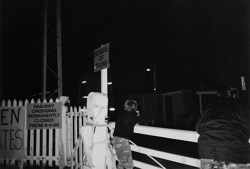
Some more statically preserved handgates at Tinning Street, Brunswick. This crossing on the Upfield line was closed in the late 90's. They're removed the road over the crossing and preserved the gates there.
https://www.google.com.au/maps/@-37.759 ... 312!8i6656

This picture from Wikipedia shows the last train to cross over the crossing before it was closed permanently.
Image

This signal has a noticeable gap in between the two set of lights on it. There must of obviously been a third pair of lights at one point in between them that were removed at some point. On the other side of the roundabout, the median signal has three pairs of lights. (Also note the mix of Westinghouse and McK&H lights.)
https://www.google.com.au/maps/@-37.944 ... 312!8i6656

Found this rural crossing which just has signs that read "BEWARE OF TRAINS".
https://www.google.com.au/maps/@-35.767 ... 328!8i1664

Looks like they plastered a newer "STOP ON RED SIGNAL" sign over an older one...
https://www.google.com.au/maps/@-35.751 ... 312!8i6656
User avatar
freebrickproductions
Posts: 9429
Joined: Thu Jun 07, 2012 11:12 am
Location: Huntsville, AL
Contact:

Re: Google Maps Scavenger Hunt

Post by freebrickproductions »

Classic cantilevers:
https://www.google.com/maps/@40.410166, ... 312!8i6656

Now here's a very classic pair of cantilever signals! Wow!
https://www.google.com/maps/@40.4175243 ... 312!8i6656

Looks like NS ain't the only one who loves tall masts!
https://www.google.com/maps/@41.2488466 ... 312!8i6656
They/Them for me, please.

Click here if you want to submit crossing photos to the site!

Avatar by runesprite on Twitter.
User avatar
ToledoRailfan
No Longer Associated With The Forum
Posts: 3315
Joined: Sun Jul 21, 2013 2:38 pm

Re: Google Maps Scavenger Hunt

Post by ToledoRailfan »

freebrickproductions wrote:Classic cantilevers:
https://www.google.com/maps/@40.410166, ... 312!8i6656

Now here's a very classic pair of cantilever signals! Wow!
https://www.google.com/maps/@40.4175243 ... 312!8i6656
Nice finds! I think I remember several classic signals from Lafayette being posted here in the past.
-----------------------------
Kind of an interesting placement for the bell. https://www.google.com/maps/@44.9419457 ... 1664?hl=en

This signals at this crossing are also classic 8'' signals! https://www.google.com/maps/@44.9419309 ... 1664?hl=en https://www.google.com/maps/@44.9419588 ... 1664?hl=en
-----------------------------
Classic 8'' signal and classic "No right/left turn" signals"! There is even a WRRS mini bell which is interestingly on the "No right turn" signal". This crossing is also on a small island, I thought that was kind of interesting.
https://www.google.com/maps/@44.9368166 ... 6656?hl=en
https://www.google.com/maps/@44.9370694 ... 6656?hl=en
https://www.google.com/maps/@44.9367041 ... 6656?hl=en
-----------------------------
This signal only has rear lights! This is due to it being on a one-way street. https://www.google.com/maps/@44.9359856 ... 1664?hl=en
-----------------------------
Kind of a strange sign setup for a private crossing, the road does look like a public road so I'm not sure if it is actually private, I don't know what they would put private crossing signs here though if is isn't private.
https://www.google.com/maps/@45.5135836 ... 6656?hl=en

The signage on the other side of the crossing is in terrible shape! https://www.google.com/maps/@45.5135308 ... 6656?hl=en
-----------------------------
Kind of funny looking.
https://www.google.com/maps/@45.5489213 ... 6656?hl=en
https://www.google.com/maps/@45.5490365 ... 6656?hl=en
-----------------------------
More classic signals.
https://www.google.com/maps/@45.641002, ... 6656?hl=en
https://www.google.com/maps/@45.641079, ... 6656?hl=en

https://www.google.com/maps/@45.672069, ... 6656?hl=en
https://www.google.com/maps/@45.6723246 ... 6656?hl=en
-----------------------------
Kind of an odd setup. First time I've seen a (for lack of a better term) half-double crossing with a third gate. This crossing also has classic signals!
https://www.google.com/maps/@45.5112065 ... 1664?hl=en
https://www.google.com/maps/@45.511314, ... 1664?hl=en
https://www.google.com/maps/@45.5114147 ... 1664?hl=en
https://www.google.com/maps/@45.512124, ... 1664?hl=en
-----------------------------
Railway Crossing!? :Blink: :Scared: I wonder if these crossbucks are originally from Canada!?
https://www.google.com/maps/@45.511676, ... 1664?hl=en
https://www.google.com/maps/@45.5121254 ... 1664?hl=en
-----------------------------
Classic gated signals.
https://www.google.com/maps/@45.4792693 ... 6656?hl=en
https://www.google.com/maps/@45.4783419 ... 6656?hl=en

https://www.google.com/maps/@45.3971616 ... 6656?hl=en
https://www.google.com/maps/@45.397513, ... 6656?hl=en
-----------------------------
Classic cantilever signals.
https://www.google.com/maps/@44.9468092 ... 1664?hl=en
https://www.google.com/maps/@44.9467409 ... 1664?hl=en
-----------------------------
8'' Western Cullen-Hayes lights!
https://www.google.com/maps/@44.8816728 ... 6656?hl=en
https://www.google.com/maps/@44.8815254 ... 6656?hl=en
User avatar
freebrickproductions
Posts: 9429
Joined: Thu Jun 07, 2012 11:12 am
Location: Huntsville, AL
Contact:

Re: Google Maps Scavenger Hunt

Post by freebrickproductions »

ToledoRailfan wrote:
freebrickproductions wrote:Classic cantilevers:
https://www.google.com/maps/@40.410166, ... 312!8i6656

Now here's a very classic pair of cantilever signals! Wow!
https://www.google.com/maps/@40.4175243 ... 312!8i6656
Nice finds! I think I remember several classic signals from Lafayette being posted here in the past.
-----------------------------
Kind of an interesting placement for the bell. https://www.google.com/maps/@44.9419457 ... 1664?hl=en

This signals at this crossing are also classic 8'' signals! https://www.google.com/maps/@44.9419309 ... 1664?hl=en https://www.google.com/maps/@44.9419588 ... 1664?hl=en
-----------------------------
Classic 8'' signal and classic "No right/left turn" signals"! There is even a WRRS mini bell which is interestingly on the "No right turn" signal". This crossing is also on a small island, I thought that was kind of interesting.
https://www.google.com/maps/@44.9368166 ... 6656?hl=en
https://www.google.com/maps/@44.9370694 ... 6656?hl=en
https://www.google.com/maps/@44.9367041 ... 6656?hl=en
-----------------------------
This signal only has rear lights! This is due to it being on a one-way street. https://www.google.com/maps/@44.9359856 ... 1664?hl=en
-----------------------------
Kind of a strange sign setup for a private crossing, the road does look like a public road so I'm not sure if it is actually private, I don't know what they would put private crossing signs here though if is isn't private.
https://www.google.com/maps/@45.5135836 ... 6656?hl=en

The signage on the other side of the crossing is in terrible shape! https://www.google.com/maps/@45.5135308 ... 6656?hl=en
-----------------------------
Kind of funny looking.
https://www.google.com/maps/@45.5489213 ... 6656?hl=en
https://www.google.com/maps/@45.5490365 ... 6656?hl=en
-----------------------------
More classic signals.
https://www.google.com/maps/@45.641002, ... 6656?hl=en
https://www.google.com/maps/@45.641079, ... 6656?hl=en

https://www.google.com/maps/@45.672069, ... 6656?hl=en
https://www.google.com/maps/@45.6723246 ... 6656?hl=en
-----------------------------
Kind of an odd setup. First time I've seen a (for lack of a better term) half-double crossing with a third gate. This crossing also has classic signals!
https://www.google.com/maps/@45.5112065 ... 1664?hl=en
https://www.google.com/maps/@45.511314, ... 1664?hl=en
https://www.google.com/maps/@45.5114147 ... 1664?hl=en
https://www.google.com/maps/@45.512124, ... 1664?hl=en
-----------------------------
Railway Crossing!? :Blink: :Scared: I wonder if these crossbucks are originally from Canada!?
https://www.google.com/maps/@45.511676, ... 1664?hl=en
https://www.google.com/maps/@45.5121254 ... 1664?hl=en
-----------------------------
Classic gated signals.
https://www.google.com/maps/@45.4792693 ... 6656?hl=en
https://www.google.com/maps/@45.4783419 ... 6656?hl=en

https://www.google.com/maps/@45.3971616 ... 6656?hl=en
https://www.google.com/maps/@45.397513, ... 6656?hl=en
-----------------------------
Classic cantilever signals.
https://www.google.com/maps/@44.9468092 ... 1664?hl=en
https://www.google.com/maps/@44.9467409 ... 1664?hl=en
-----------------------------
8'' Western Cullen-Hayes lights!
https://www.google.com/maps/@44.8816728 ... 6656?hl=en
https://www.google.com/maps/@44.8815254 ... 6656?hl=en
Lots of mini-bells there.
Also, it's entirely possible that the RailWAY Crossing crossbucks originated here in the US. I found a picture a little while back showing downtown Madison, AL back before signals were ever installed there at the Church Street crossing, and it shows a crossbuck that says "Railway Crossing".
They/Them for me, please.

Click here if you want to submit crossing photos to the site!

Avatar by runesprite on Twitter.
Post Reply