
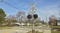
Active crossing in Cleveland, TN:
https://www.google.com/maps/@35.1232722 ... 312!8i6656
Google Maps Scavenger Hunt
Moderators: freebrickproductions, mlgillson, PlyingKibbles89, Raco_GS, Hopen111, TommyBNSF
-
freebrickproductions

- Posts: 9419
- kuchnie-na-wymiar.wroclaw.pl
- Joined: Thu Jun 07, 2012 11:12 am
- Location: Huntsville, AL
- Contact:
Re: Google Maps Scavenger Hunt
They/Them for me, please.
Click here if you want to submit crossing photos to the site!
Avatar by runesprite on Twitter.
Click here if you want to submit crossing photos to the site!
Avatar by runesprite on Twitter.

Re: Google Maps Scavenger Hunt
Left handed setup in Edison, NJ... I'm guessing due to the road at the right. https://www.google.com/maps/@40.5123632 ... 56!6m1!1e1. This may have been posted before... if so... sorry for the repeat.
Hello there! https://www.google.com/maps/@40.5184707 ... 56!6m1!1e1.
Still at work when the Google car came back the other way... https://www.google.com/maps/@40.5185472 ... 56!6m1!1e1
Interesting how far up this traffic signal is from the rest of the intersection. Almost a full block... https://www.google.com/maps/@40.5068635 ... 56!6m1!1e1
 https://www.google.com/maps/@40.5174793 ... 56!6m1!1e1
Hello there! https://www.google.com/maps/@40.5184707 ... 56!6m1!1e1.
Still at work when the Google car came back the other way... https://www.google.com/maps/@40.5185472 ... 56!6m1!1e1
Interesting how far up this traffic signal is from the rest of the intersection. Almost a full block... https://www.google.com/maps/@40.5068635 ... 56!6m1!1e1
https://www.google.com/maps/@40.5174793 ... 56!6m1!1e1-
ToledoRailfan
- No Longer Associated With The Forum
- Posts: 3315
- Joined: Sun Jul 21, 2013 2:38 pm
Re: Google Maps Scavenger Hunt
Crossings that are close to intersections are not uncommon in Michigan therefor so are Preemption signals but every now and then there are some that for some reason are very far from the intersection, I've always thought it was weird. Although I think the crossing that you found has Preemption signals even though it is so far from the intersection may have to do with the crossing being close to entrances for retail parking. These advanced warning signs near the crossing are kind of strange too. https://www.google.com/maps/@40.5063362 ... 312!8i6656 https://www.google.com/maps/@40.5073163 ... 312!8i6656cabman701 wrote: Interesting how far up this traffic signal is from the rest of the intersection. Almost a full block... https://www.google.com/maps/@40.5068635 ... 56!6m1!1e1

Re: Google Maps Scavenger Hunt
If I had to guess, these signals serve the line right there and go red when there's a train on them. Either that, or they're tied to the light up ahead, and changes to red before the main light to prevent stopped traffic on the tracks.cabman701 wrote:Interesting how far up this traffic signal is from the rest of the intersection. Almost a full block... https://www.google.com/maps/@40.5068635 ... 56!6m1!1e1
Crossing pictures from Plant City, FL are finally here! viewtopic.php?f=13&t=2538
-
TrickyMario7654

- Posts: 1360
- Joined: Fri Aug 26, 2016 6:45 pm
- Location: Melbourne, Australia
Re: Google Maps Scavenger Hunt
Active crossing with a train going through it in Melbourne, Australia (This one's at Burke Road, also note the Connex colors on the train? Operations of the network were taken over by Metro Trains Melbourne in late-2009): https://www.google.com.au/maps/@-37.853 ... 328!8i1664
Metro, why do you keep removing Mechanical bells?!
Click here if you want to see which crossings haven't been ruined by Metro Trains bell nazis.
Click here if you want to see which crossings haven't been ruined by Metro Trains bell nazis.
Re: Google Maps Scavenger Hunt
Welcome to the forums!TrickyMario7654 wrote:Active crossing with a train going through it in Melbourne, Australia (This one's at Burke Road, also note the Connex colors on the train? Operations of the network were taken over by Metro Trains Melbourne in late-2009): https://www.google.com.au/maps/@-37.853 ... 328!8i1664
Looks like the crossing was caught in action on the photo sphere as well:
https://www.google.com/maps/@-37.853424 ... 240!8i5120
Crossing pictures from Plant City, FL are finally here! viewtopic.php?f=13&t=2538
-
TrickyMario7654
- Posts: 1360
- Joined: Fri Aug 26, 2016 6:45 pm
- Location: Melbourne, Australia
Re: Google Maps Scavenger Hunt
@ZachL: Thanks! The crossing at Burke Road is no more now as the crossing was grade separated earlier this year. 
Anyways, here are some more active crossings I've found.
Melba Avenue (Nov 2009): https://www.google.com.au/maps/@-37.760 ... 312!8i6656
Tooronga Road (Dec 2009): https://www.google.com.au/maps/@-37.849 ... 312!8i6656
Glenferrie Road (Aug 2014, train can be seen too!): https://www.google.com.au/maps/@-37.839 ... 312!8i6656
Union Road (Aug 2014): https://www.google.com.au/maps/@-37.824 ... 312!8i6656
Mont Albert Road (Dec 2007): https://www.google.com.au/maps/@-37.821 ... 328!8i1664
Same crossing in Dec 2009: https://www.google.com.au/maps/@-37.821 ... 312!8i6656
Heatherdale Road (Jan 2008, looks like a train had just been through): https://www.google.com.au/maps/@-37.818 ... 328!8i1664
Hampton Street (Aug 2015): https://www.google.com.au/maps/@-37.938 ... 312!8i6656
Snapped at the same crossing just as the gates were either lowering or raising (Also contains a daredevil driver too!): https://www.google.com.au/maps/@-37.938 ... 312!8i6656
Abbott Street (Aug 2008): https://www.google.com.au/maps/@-37.948 ... 328!8i1664
Another shot: https://www.google.com.au/maps/@-37.948 ... 328!8i1664
McKinnon Road (Jan 2010, this one has been grade separated too! ): https://www.google.com.au/maps/@-37.911 ... 312!8i6656
North Road (June 2013, yet another crossing that's been grade separated ): https://www.google.com.au/maps/@-37.904 ... 312!8i6656
Anyways, here are some more active crossings I've found.
Melba Avenue (Nov 2009): https://www.google.com.au/maps/@-37.760 ... 312!8i6656
Tooronga Road (Dec 2009): https://www.google.com.au/maps/@-37.849 ... 312!8i6656
Glenferrie Road (Aug 2014, train can be seen too!): https://www.google.com.au/maps/@-37.839 ... 312!8i6656
Union Road (Aug 2014): https://www.google.com.au/maps/@-37.824 ... 312!8i6656
Mont Albert Road (Dec 2007): https://www.google.com.au/maps/@-37.821 ... 328!8i1664
Same crossing in Dec 2009: https://www.google.com.au/maps/@-37.821 ... 312!8i6656
Heatherdale Road (Jan 2008, looks like a train had just been through): https://www.google.com.au/maps/@-37.818 ... 328!8i1664
Hampton Street (Aug 2015): https://www.google.com.au/maps/@-37.938 ... 312!8i6656
Snapped at the same crossing just as the gates were either lowering or raising (Also contains a daredevil driver too!): https://www.google.com.au/maps/@-37.938 ... 312!8i6656
Abbott Street (Aug 2008): https://www.google.com.au/maps/@-37.948 ... 328!8i1664
Another shot: https://www.google.com.au/maps/@-37.948 ... 328!8i1664
McKinnon Road (Jan 2010, this one has been grade separated too!
): https://www.google.com.au/maps/@-37.911 ... 312!8i6656North Road (June 2013, yet another crossing that's been grade separated
): https://www.google.com.au/maps/@-37.904 ... 312!8i6656Metro, why do you keep removing Mechanical bells?!
Click here if you want to see which crossings haven't been ruined by Metro Trains bell nazis.
Click here if you want to see which crossings haven't been ruined by Metro Trains bell nazis.
-
freebrickproductions
- Posts: 9419
- Joined: Thu Jun 07, 2012 11:12 am
- Location: Huntsville, AL
- Contact:
Re: Google Maps Scavenger Hunt
A lot of incandescent lights in those links too! Nice finds!TrickyMario7654 wrote:@ZachL: Thanks! The crossing at Burke Road is no more now as the crossing was grade separated earlier this year.
Anyways, here are some more active crossings I've found.
Melba Avenue (Nov 2009): https://www.google.com.au/maps/@-37.760 ... 312!8i6656
Tooronga Road (Dec 2009): https://www.google.com.au/maps/@-37.849 ... 312!8i6656
Glenferrie Road (Aug 2014, train can be seen too!): https://www.google.com.au/maps/@-37.839 ... 312!8i6656
Union Road (Aug 2014): https://www.google.com.au/maps/@-37.824 ... 312!8i6656
Mont Albert Road (Dec 2007): https://www.google.com.au/maps/@-37.821 ... 328!8i1664
Same crossing in Dec 2009: https://www.google.com.au/maps/@-37.821 ... 312!8i6656
Heatherdale Road (Jan 2008, looks like a train had just been through): https://www.google.com.au/maps/@-37.818 ... 328!8i1664
Hampton Street (Aug 2015): https://www.google.com.au/maps/@-37.938 ... 312!8i6656
Snapped at the same crossing just as the gates were either lowering or raising (Also contains a daredevil driver too!): https://www.google.com.au/maps/@-37.938 ... 312!8i6656
Abbott Street (Aug 2008): https://www.google.com.au/maps/@-37.948 ... 328!8i1664
Another shot: https://www.google.com.au/maps/@-37.948 ... 328!8i1664
McKinnon Road (Jan 2010, this one has been grade separated too!
North Road (June 2013, yet another crossing that's been grade separated
They/Them for me, please.
Click here if you want to submit crossing photos to the site!
Avatar by runesprite on Twitter.
Click here if you want to submit crossing photos to the site!
Avatar by runesprite on Twitter.
-
freebrickproductions
- Posts: 9419
- Joined: Thu Jun 07, 2012 11:12 am
- Location: Huntsville, AL
- Contact:
Re: Google Maps Scavenger Hunt
Google caught 18th Avenue in Nashville, TN in action!
https://www.google.com/maps/@36.162381, ... 6656?hl=en
A crossing out near Leighton, AL in action:
https://www.google.com/maps/@34.6974152 ... 6656?hl=en
The train was NS 325 with NS, UP, and BNSF power:
https://www.google.com/maps/@34.6973989 ... 6656?hl=en
https://www.google.com/maps/@36.162381, ... 6656?hl=en
A crossing out near Leighton, AL in action:
https://www.google.com/maps/@34.6974152 ... 6656?hl=en
The train was NS 325 with NS, UP, and BNSF power:
https://www.google.com/maps/@34.6973989 ... 6656?hl=en
They/Them for me, please.
Click here if you want to submit crossing photos to the site!
Avatar by runesprite on Twitter.
Click here if you want to submit crossing photos to the site!
Avatar by runesprite on Twitter.
-
TrickyMario7654
- Posts: 1360
- Joined: Fri Aug 26, 2016 6:45 pm
- Location: Melbourne, Australia
Re: Google Maps Scavenger Hunt
Some more active crossing finds:
Maddox Road (Nov 2009): https://www.google.com.au/maps/@-37.848 ... 312!8i6656
Champion Road (Dec 2007): https://www.google.com.au/maps/@-37.848 ... 328!8i1664
Kororoit Creek Road (Nov 2009, train can be seen at the crossing, taken less than a month before Metro Trains took over the system): https://www.google.com.au/maps/@-37.857 ... 312!8i6656
More shots: https://www.google.com.au/maps/@-37.857 ... 312!8i6656
https://www.google.com.au/maps/@-37.857 ... 312!8i6656
Giffard Street (Dec 2007): https://www.google.com.au/maps/@-37.865 ... 328!8i1664
Main Road (Jul 2014, 16 people have died here over the past few decades!): https://www.google.com.au/maps/@-37.744 ... 312!8i6656
Hudsons Road (Jun 2014, looks like the gates are raising): https://www.google.com.au/maps/@-37.829 ... 312!8i6656
Anderson Street (Nov 2007, train can be seen too!): https://www.google.com.au/maps/@-37.816 ... 328!8i1664
Clayton Road (Dec 2007, the barriers are likely raising at this location): https://www.google.com.au/maps/@-37.924 ... 328!8i1664
High Street (Sep 2014, the most confusing crossing ever!): https://www.google.com.au/maps/@-37.715 ... 312!8i6656
McDonald Street (Nov 2007, you can see the train approaching the crossing): https://www.google.com.au/maps/@-38.005 ... 328!8i1664
Groves Street (Nov 2014): https://www.google.com.au/maps/@-38.027 ... 312!8i6656
The same crossing (but with a train going through it) in Jul 2015: https://www.google.com.au/maps/@-38.027 ... 312!8i6656
another shot: https://www.google.com.au/maps/@-38.027 ... 312!8i6656
Yet another instance of this crossing activated (Dec 2009): https://www.google.com.au/maps/@-38.027 ... 312!8i6656
Lochiel Avenue (Jul 2015): https://www.google.com.au/maps/@-38.034 ... 312!8i6656
Same crossing in (Nov 2014): https://www.google.com.au/maps/@-38.034 ... 312!8i6656
Edithvale Road (Nov 2007): https://www.google.com.au/maps/@-38.038 ... 328!8i1664
Again in Dec 2009: https://www.google.com.au/maps/@-38.038 ... 312!8i6656
Another shot, but this time with a train. (Also note the temporary Metro stickers on the train? They were used to cover up Connex's logos until they were given proper Metro colors: https://www.google.com.au/maps/@-38.038 ... 312!8i6656
Another train (this time a Comeng model) going through the crossing in Dec 2009: https://www.google.com.au/maps/@-38.038 ... 312!8i6656
And again in Feb 2010: https://www.google.com.au/maps/@-38.038 ... 312!8i6656
Swanpool Avenue (Oct 2015): https://www.google.com.au/maps/@-38.047 ... 312!8i6656
Chelsea Road (Jan 2010, barriers are lowering): https://www.google.com.au/maps/@-38.051 ... 312!8i6656
Station Street (Sep 2015, train going through the crossing): https://www.google.com.au/maps/@-38.074 ... 312!8i6656
Eel Race Road (Sep 2015): https://www.google.com.au/maps/@-38.082 ... 312!8i6656
Armstorngs Road (Dec 2009, a train can be seen crossing the road): https://www.google.com.au/maps/@-38.093 ... 312!8i6656
Normanby Avenue (Apr 2015, train can be seen passing through): https://www.google.com.au/maps/@-37.759 ... 312!8i6656
Puckle Street (Nov 2007, train can be seen at the station): https://www.google.com.au/maps/@-37.766 ... 328!8i1664
Buckley Street (May 2014): https://www.google.com.au/maps/@-37.756 ... 312!8i6656
Maddox Road (Nov 2009): https://www.google.com.au/maps/@-37.848 ... 312!8i6656
Champion Road (Dec 2007): https://www.google.com.au/maps/@-37.848 ... 328!8i1664
Kororoit Creek Road (Nov 2009, train can be seen at the crossing, taken less than a month before Metro Trains took over the system): https://www.google.com.au/maps/@-37.857 ... 312!8i6656
More shots: https://www.google.com.au/maps/@-37.857 ... 312!8i6656
https://www.google.com.au/maps/@-37.857 ... 312!8i6656
Giffard Street (Dec 2007): https://www.google.com.au/maps/@-37.865 ... 328!8i1664
Main Road (Jul 2014, 16 people have died here over the past few decades!): https://www.google.com.au/maps/@-37.744 ... 312!8i6656
Hudsons Road (Jun 2014, looks like the gates are raising): https://www.google.com.au/maps/@-37.829 ... 312!8i6656
Anderson Street (Nov 2007, train can be seen too!): https://www.google.com.au/maps/@-37.816 ... 328!8i1664
Clayton Road (Dec 2007, the barriers are likely raising at this location): https://www.google.com.au/maps/@-37.924 ... 328!8i1664
High Street (Sep 2014, the most confusing crossing ever!): https://www.google.com.au/maps/@-37.715 ... 312!8i6656
McDonald Street (Nov 2007, you can see the train approaching the crossing): https://www.google.com.au/maps/@-38.005 ... 328!8i1664
Groves Street (Nov 2014): https://www.google.com.au/maps/@-38.027 ... 312!8i6656
The same crossing (but with a train going through it) in Jul 2015: https://www.google.com.au/maps/@-38.027 ... 312!8i6656
another shot: https://www.google.com.au/maps/@-38.027 ... 312!8i6656
Yet another instance of this crossing activated (Dec 2009): https://www.google.com.au/maps/@-38.027 ... 312!8i6656
Lochiel Avenue (Jul 2015): https://www.google.com.au/maps/@-38.034 ... 312!8i6656
Same crossing in (Nov 2014): https://www.google.com.au/maps/@-38.034 ... 312!8i6656
Edithvale Road (Nov 2007): https://www.google.com.au/maps/@-38.038 ... 328!8i1664
Again in Dec 2009: https://www.google.com.au/maps/@-38.038 ... 312!8i6656
Another shot, but this time with a train. (Also note the temporary Metro stickers on the train? They were used to cover up Connex's logos until they were given proper Metro colors: https://www.google.com.au/maps/@-38.038 ... 312!8i6656
Another train (this time a Comeng model) going through the crossing in Dec 2009: https://www.google.com.au/maps/@-38.038 ... 312!8i6656
And again in Feb 2010: https://www.google.com.au/maps/@-38.038 ... 312!8i6656
Swanpool Avenue (Oct 2015): https://www.google.com.au/maps/@-38.047 ... 312!8i6656
Chelsea Road (Jan 2010, barriers are lowering): https://www.google.com.au/maps/@-38.051 ... 312!8i6656
Station Street (Sep 2015, train going through the crossing): https://www.google.com.au/maps/@-38.074 ... 312!8i6656
Eel Race Road (Sep 2015): https://www.google.com.au/maps/@-38.082 ... 312!8i6656
Armstorngs Road (Dec 2009, a train can be seen crossing the road): https://www.google.com.au/maps/@-38.093 ... 312!8i6656
Normanby Avenue (Apr 2015, train can be seen passing through): https://www.google.com.au/maps/@-37.759 ... 312!8i6656
Puckle Street (Nov 2007, train can be seen at the station): https://www.google.com.au/maps/@-37.766 ... 328!8i1664
Buckley Street (May 2014): https://www.google.com.au/maps/@-37.756 ... 312!8i6656
Metro, why do you keep removing Mechanical bells?!
Click here if you want to see which crossings haven't been ruined by Metro Trains bell nazis.
Click here if you want to see which crossings haven't been ruined by Metro Trains bell nazis.