Its gone now.
https://www.google.com/maps/@53.3980061 ... 312!8i6656
Heres an abandoned spur line, near Manchester. It's laid defunct for around 10 years. I believe it used to serve an oil plant which is still running, but i guess they decided to end their contract of trains running on the line. Another section of the spur lead to some sort of reproduction plant or something. It was there in 2008 defunct, but by May 2012. It had been demolished. The site is now a car park and a site for oil tankers to be picked up.
https://www.google.co.uk/maps/@53.47119 ... 312!8i6656
https://www.google.co.uk/maps/@53.47124 ... 312!8i6656
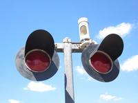
The first crossing has no signals nor a St Andrews cross on any sides of the signals.
Heres the first crossing, pretty bad view. I apologize.
https://www.google.co.uk/maps/@53.47750 ... 312!8i6656
The tracks were still in a reasonable condition in July 2014.
https://www.google.co.uk/maps/@53.47701 ... 312!8i6656
However, they were gone when Google came back 10 months later. Some of the ties were still there however.
https://www.google.co.uk/maps/@53.47701 ... 312!8i6656
The next crossing has the same stuff, no signals, no nothing. The only thing that catches my eye is this.
https://www.google.co.uk/maps/@53.47665 ... 312!8i6656
This crossing is blocked by a gate.
https://www.google.co.uk/maps/@53.47604 ... 312!8i6656
Theres still a section of track here!
https://www.google.co.uk/maps/@53.47604 ... 312!8i6656
This crossing is blocked by a barrier, this is used to by electricians to service this substation.
https://www.google.co.uk/maps/@53.47572 ... 312!8i6656
https://www.google.co.uk/maps/@53.47572 ... 312!8i6656
This crossing is blocked by a fence.
https://www.google.co.uk/maps/@53.47552 ... 312!8i6656
I believe this is where the crossing would get activated, i doubt it works.
https://www.google.co.uk/maps/@53.47552 ... 312!8i6656
Back in 2008, there was a sign where trains had to stop, and await instructions.
https://www.google.co.uk/maps/@53.47555 ... 312!8i6656
This crossing has a newish looking grade.
https://www.google.co.uk/maps/@53.47545 ... 312!8i6656
This crossing still has its white light!
https://www.google.co.uk/maps/@53.47545 ... 312!8i6656
This is a weird crossing. For some reason, theres 2 alarms on this signal.
https://www.google.co.uk/maps/@53.47512 ... 312!8i6656
This crossing has a pedestrian light.
https://www.google.co.uk/maps/@53.47516 ... 312!8i6656
There used to be a DOT tag saying to contact TFE, but i'm not sure what that is.
https://www.google.co.uk/maps/@53.47516 ... 312!8i6656
I wonder if these are the relay cases?
https://www.google.co.uk/maps/@53.47490 ... 312!8i6656
This crossing has a cantilever!
https://www.google.co.uk/maps/@53.47444 ... 312!8i6656