Here's an abandoned section of the Arkansas-Oklahoma Railroad subdivision heading east out of Shawnee, OK.
This first crossing is mostly intact, save for the lack of any signage:
https://www.google.com/maps/@35.3114638 ... 312!8i6656
This next crossing has had the rails paved over and the signals removed, though the relay case and foundations (with guard-rails) still remain:
https://www.google.com/maps/@35.3042434 ... 312!8i6656
I was just barely able to make out the DOT number on the side of the relay case (597056U), and the last inventory report filed with the FRA was in 2000, though it wasn't to officially mark the crossing as closed, surprisingly:
https://www.google.com/maps/@35.3042469 ... 312!8i6656
Another crossing in the same shape as the one above:
https://www.google.com/maps/@35.3012457 ... 312!8i6656
Other than the rails around the crossing, not much left here, though it likely originally had crossbucks:
https://www.google.com/maps/@35.295453, ... 312!8i6656
https://www.google.com/maps/@35.2953548 ... 312!8i6656
https://www.google.com/maps/@35.2953548 ... 312!8i6656
Same situation at this crossing:
https://www.google.com/maps/@35.2896568 ... 312!8i6656
https://www.google.com/maps/@35.2896561 ... 312!8i6656
https://www.google.com/maps/@35.2896561 ... 312!8i6656
Another formerly signalized crossing, that has since been mostly torn out:
https://www.google.com/maps/@35.2849808 ... 312!8i6656
The line turns south into Earsboro, OK, where we find the remains of half of a crossbuck:
https://www.google.com/maps/@35.2678977 ... 312!8i6656
A bit further south, we find another crossbuck crossing, with both crossbucks still standing:
https://www.google.com/maps/@35.2656825 ... 312!8i6656
The line then crosses over US 270 on a bridge:
https://www.google.com/maps/@35.2605782 ... 312!8i6656
https://www.google.com/maps/@35.2605782 ... 312!8i6656
The line then turns back east, and we come across this crossing with what appears to have once been a passing siding:
https://www.google.com/maps/@35.2443493 ... 312!8i6656
This crossing has been paved over, but some rails still remain around it and can just barely be made out amongst all of the grass and other plants:
https://www.google.com/maps/@35.2319403 ... 328!8i1664
https://www.google.com/maps/@35.2319398 ... 328!8i1664
Heading into Seminole, we find this abandoned crossing which retains the remains of a pair of cantilevers:
https://www.google.com/maps/@35.2222946 ... 312!8i6656
https://www.google.com/maps/@35.2224647 ... 312!8i6656
They were a little more complete back in 2013:
https://www.google.com/maps/@35.2222272 ... 312!8i6656
The old Rock Island(?) depot still stands in Seminole, and it's now a Mexican restaurant:
https://www.google.com/maps/@35.2229198 ... 312!8i6656
Another former signalized crossing to the east of the town:
https://www.google.com/maps/@35.223788, ... 312!8i6656
The relay case has a DOT number on it, but unfortunately, I can't make out the first three numbers. Would be interesting to see if the FRA has a report as to when this was abandoned though:
https://www.google.com/maps/@35.2238883 ... 312!8i6656
The line then passes underneath US 270 a bit further east:
https://www.google.com/maps/@35.1738449 ... 312!8i6656
There was a former grade crossing just west of there, but nothing of the old line could be made out!
The line then passes underneath the old alignment of US 270, as you can kinda see here:
https://www.google.com/maps/@35.1744965 ... 328!8i1664
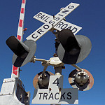
Heading into Wewoka, we find this Rock Island WRRS install that's pretty much intact, aside from the lack of gate arms (and the fact that the signals had the lights upgraded to WCH 12x20s at some point):
https://www.google.com/maps/@35.1618883 ... 312!8i6656
Just ot the east of that, we find this rather wide gateless install with a US&S Teardrop bell!
https://www.google.com/maps/@35.1609152 ... 312!8i6656
https://www.google.com/maps/@35.1612706 ... 312!8i6656
https://www.google.com/maps/@35.1609934 ... 312!8i6656
Also, one of the lights here broke off, but not quite, apparently:
https://www.google.com/maps/@35.1609934 ... 312!8i6656
And just north of that crossing is an abandoned spur:
https://www.google.com/maps/@35.1613392 ... 312!8i6656
https://www.google.com/maps/@35.1613392 ... 312!8i6656
Continuing east, we find this abandoned crossbuck that likely originally had crossbucks:
https://www.google.com/maps/@35.1448966 ... 312!8i6656
https://www.google.com/maps/@35.1448966 ... 312!8i6656
https://www.google.com/maps/@35.1448966 ... 312!8i6656
Heading into Holdenville, OK, now. This crossing likely originally had crossbucks as well:
https://www.google.com/maps/@35.0940141 ... 312!8i6656
Further to the southeast, we find this rather intact crossbuck crossing:
https://www.google.com/maps/@35.0868041 ... 312!8i6656
Only one crossbuck remains at the next crossing over:
https://www.google.com/maps/@35.0859556 ... 312!8i6656
Just to the SE, the line crosses an active BNSF line. Interestingly enough, the signals for the AOK/CRIP line still stand while BNSF removed the ones facing their line.
Also of note, is that it appears that these signals still retain power, as the one facing southeast still have a light lit!
https://www.google.com/maps/@35.0860693 ... 312!8i6656
https://www.google.com/maps/@35.0835812 ... 312!8i6656
There's also an abandoned gateless crossing on the other side of the diamond, with a pair of split cast-iron crossbucks!
https://www.google.com/maps/@35.0836936 ... 312!8i6656
Another couple of crossbuck crossings past that:
https://www.google.com/maps/@35.0828352 ... 312!8i6656
https://www.google.com/maps/@35.0819875 ... 312!8i6656
Not sure what this relay case near this first one is for, possibly a fixed approach signal?
https://www.google.com/maps/@35.0827828 ... 312!8i6656
Another WRRS install, though the signals here are in a bit worse shape:
https://www.google.com/maps/@35.0811866 ... 312!8i6656
Another crossbuck crossing, with one crossing in good shape, but the other is missing from the post and has had the Tracks sign wrapped around the post:
https://www.google.com/maps/@35.0792856 ... 312!8i6656
https://www.google.com/maps/@35.0795414 ... 312!8i6656
Another crossbuck, though both crossbucks are missing from the post here:
https://www.google.com/maps/@35.077826, ... 312!8i6656
Continuing to the southeast we find this crossing that doesn't have much left at it:
https://www.google.com/maps/@35.0722427 ... 312!8i6656
The line then passes underneath OK 48:
https://www.google.com/maps/@35.0080573 ... 312!8i6656
Further to the east in Calvin, OK, we come across this pair of slightly beat-up bell-less, gateless signals that are pretty far apart:
https://www.google.com/maps/@34.9704578 ... 312!8i6656
https://www.google.com/maps/@34.969935, ... 312!8i6656
Looks like this lens is broken:
https://www.google.com/maps/@34.9701731 ... 312!8i6656
The line then passes underneath US 270 again, though this time the highway is duplexed with US 75:
https://www.google.com/maps/@34.9674828 ... 312!8i6656
And then it passes back over US 270/OK 1 on this rather cool bridge with Rock Island Lines still painted on the side:
https://www.google.com/maps/@34.9436677 ... 312!8i6656
And then in Stuart, OK, we find this pair of gateless signals:
https://www.google.com/maps/@34.9039451 ... 328!8i1664
https://www.google.com/maps/@34.9041256 ... 328!8i1664
Looks like they're still standing as of 2018 as well:
https://www.google.com/maps/@34.9058008 ... 312!8i6656
Further east, over in Haywood, OK, we find this CRIP WRRS install, that still retains both gate arms!
https://www.google.com/maps/@34.8869353 ... 312!8i6656
Looks like UP was the last owner of this crossing:
https://www.google.com/maps/@34.8872988 ... 312!8i6656
Looking up the DOT number for the crossing (600202E) reveals that this crossing was closed in 2004 by UP.
Further east, we find this crossbuck crossing:
https://www.google.com/maps/@34.8869431 ... 312!8i6656
We then cross OK 31 again at this former crossbuck crossing, which has since had the crossbucks removed:
https://www.google.com/maps/@34.8986152 ... 312!8i6656
Back when the crossbucks were still standing in 2008:
https://www.google.com/maps/@34.8985925 ... 328!8i1664
Just to the east of this crossing is a line of stored cars, which have since been removed:
https://www.google.com/maps/@34.8986188 ... 312!8i6656
Once you get into McAlister, OK, the line goes back into service under the Arkansas-Oklahoma Railroad again. On the eastern end of this segment though, the line is completely abandoned and torn up, with the only thing being left is the ROW as it heads into Arkansas. However, at the eastern end of the AOK's active section, the track still leads up to where a diamond used to be, with an abandoned block signal still standing next to the tracks:
https://www.google.com/maps/@34.9557851 ... 312!8i6656