
Here's a dead crossing in New Jersey still owned by Conrail. Looks like one of the signals got wiped-out by a car between 2020 and 2021
https://www.google.com/maps/@40.4800651 ... ?entry=ttu
Going west one crossing you can see that the tracks have since ripped from the road as well.
https://www.google.com/maps/@40.4848504 ... ?entry=ttu
The next crossing west of that still retains the rails in the road, but with some interesting signs posted at it.
https://www.google.com/maps/@40.486582, ... ?entry=ttu
Tracks out of service
Moderators: freebrickproductions, mlgillson, PlyingKibbles89, Raco_GS, Hopen111, TommyBNSF
-
freebrickproductions

- Posts: 9483
- kuchnie-na-wymiar.wroclaw.pl
- Joined: Thu Jun 07, 2012 11:12 am
- Location: Huntsville, AL
- Contact:
Re: Tracks out of service
They/Them for me, please.
Click here if you want to submit crossing photos to the site!
Avatar by runesprite on Twitter.
Click here if you want to submit crossing photos to the site!
Avatar by runesprite on Twitter.

Re: Tracks out of service
freebrickproductions wrote: Fri Sep 22, 2023 12:21 pm The next crossing west of that still retains the rails in the road, but with some interesting signs posted at it.
https://www.google.com/maps/@40.486582, ... ?entry=ttu
Curious who the authority is then on that crossing if a bicyclist would hit one of those chuckholes over the old rails and crack their skull open. Is that the city saying blame Conrail because they paved over the crossing and didn't remove the rails? Or maybe the city trying to cover up something they don't want to spend the money to fix, but it's technically their issue because they paved it over in the first place. Every state seems to have different rules as to who and what pays for different pieces of a crossing.
Well, 
-
freebrickproductions
- Posts: 9483
- Joined: Thu Jun 07, 2012 11:12 am
- Location: Huntsville, AL
- Contact:
Re: Tracks out of service
Was looking around on Google Maps and found this dead branch line in Florida, branching off of what appears to be the A Line. The first crossing along it is with US 17 and still appears to be in decent shape:
https://www.google.com/maps/@29.8714911 ... ?entry=ttu
The signals appear to be in decent shape so I wouldn't be too surprised if they're still maintained. The tracks around it don't appear to be too overgrown either, I suppose it's entirely possible CSX still uses this part of the line for a bit of car storage.
Going west to Warner Road, there's this crossing that features a pair of gateless Harmon cantilevers from the SCL that are also in decent shape still, but the tracks here are much more heavily overgrown:
https://www.google.com/maps/@29.8679933 ... ?entry=ttu
It seems the line unceremoniously ends not too much further to the west, I'm guessing about where the plant it appears to have once served once stood.
https://www.google.com/maps/@29.8714911 ... ?entry=ttu
The signals appear to be in decent shape so I wouldn't be too surprised if they're still maintained. The tracks around it don't appear to be too overgrown either, I suppose it's entirely possible CSX still uses this part of the line for a bit of car storage.
Going west to Warner Road, there's this crossing that features a pair of gateless Harmon cantilevers from the SCL that are also in decent shape still, but the tracks here are much more heavily overgrown:
https://www.google.com/maps/@29.8679933 ... ?entry=ttu
It seems the line unceremoniously ends not too much further to the west, I'm guessing about where the plant it appears to have once served once stood.
They/Them for me, please.
Click here if you want to submit crossing photos to the site!
Avatar by runesprite on Twitter.
Click here if you want to submit crossing photos to the site!
Avatar by runesprite on Twitter.
Re: Tracks out of service
Found some "ghosts of signals past" in the Fredonia, KS area.
Remains of three signals here, one crossbuck and inverted "3 Tracks" sign remain, along with the relay case. Per a post I found on the Abandoned Rails Facebook group, this was an ex-Santa Fe line.
https://maps.app.goo.gl/irLVmvpFzaGHTWRv6
Moving south, here's a crossbuck that was just thrown in the bushes. There were actually two rights-of-way running parallel here, this is on the one to the east.
https://maps.app.goo.gl/adNQWEtTcatxa9k48
Looking at the Street View image history, it looks like the one to the west was actually out of service, then rebuilt starting around 2014. It cuts over to the east and uses a portion of the other RoW to serve a grain elevator on the far north edge of town. Looks like the original crossing between the two lines would have been just south of US 400.
Continuing south, this crossing has a relay case with a wire still going to it and the concrete remains of a battery box, but no traces of signals, just crossbucks on wooden posts. Looking at the history, that was the case back in 2014, as well.
https://maps.app.goo.gl/en6quxQdxnrfrNbm6
Traces of rail are still visible on the other RoW to the east:
https://maps.app.goo.gl/B7qpHmvZ8xsreZbW9
The only crossing along this stretch that appears to have active signals:
https://maps.app.goo.gl/weyJy8xiCdoC6RLb6
Continuing south, a relay case on a post (with a crossbuck on the front) with a wire going to it, and another battery box, but no actual warning devices. Looking at the post, maybe this was once a bell-only crossing but the bell was removed/stolen?
https://maps.app.goo.gl/LPf3H1b4ka9oPR5C8
More traces of rail on the parallel RoW to the east. Also check out the mural on the building to the right!
https://maps.app.goo.gl/YEAVvSz5gSc5tK3dA
Judging from the preserved depot and caboose, this was a Missouri Pacific line:
https://maps.app.goo.gl/dF4n6MmE8THNfS279
The next crossing south on the ex-Santa Fe has another orphaned relay case and battery box:
https://maps.app.goo.gl/6hAmL8Wv3Xn3FFnM9
Similar situation at the next one south, but the relay case is gone:
https://maps.app.goo.gl/tYLgw8gsPiZLo8Dw6
Looks like an orphaned advance warning sign for the long gone ex-MoPac crossing to the east, but it has a blue tag on it with the DOT number for the ex-ATSF crossing!
https://maps.app.goo.gl/d7B6YgRymQDZLWEe7
Back in 2014, there was no trace of active rail here at all!
https://maps.app.goo.gl/XLk95ZcpFAZrEUDD7
On the southwest side of town there was a crossing between the ex-Santa Fe line and a St.Louis-San Francisco (Frisco) line that came in from the southeast and then went west through New Albany, Fall River, Severy, etc. (Google's map view erroneously shows parts of this line as still existing despite its having been gone for at least 20 years). I found this. Possibly the remains of a wigwag?
https://maps.app.goo.gl/sysUyBvSihBc62PC9
Thought it might have been a US&S wigwag like the one that was in Joplin, MO (also an ex-Frisco line), but the box on the mast looks different.
Remains of three signals here, one crossbuck and inverted "3 Tracks" sign remain, along with the relay case. Per a post I found on the Abandoned Rails Facebook group, this was an ex-Santa Fe line.
https://maps.app.goo.gl/irLVmvpFzaGHTWRv6
Moving south, here's a crossbuck that was just thrown in the bushes. There were actually two rights-of-way running parallel here, this is on the one to the east.
https://maps.app.goo.gl/adNQWEtTcatxa9k48
Looking at the Street View image history, it looks like the one to the west was actually out of service, then rebuilt starting around 2014. It cuts over to the east and uses a portion of the other RoW to serve a grain elevator on the far north edge of town. Looks like the original crossing between the two lines would have been just south of US 400.
Continuing south, this crossing has a relay case with a wire still going to it and the concrete remains of a battery box, but no traces of signals, just crossbucks on wooden posts. Looking at the history, that was the case back in 2014, as well.
https://maps.app.goo.gl/en6quxQdxnrfrNbm6
Traces of rail are still visible on the other RoW to the east:
https://maps.app.goo.gl/B7qpHmvZ8xsreZbW9
The only crossing along this stretch that appears to have active signals:
https://maps.app.goo.gl/weyJy8xiCdoC6RLb6
Continuing south, a relay case on a post (with a crossbuck on the front) with a wire going to it, and another battery box, but no actual warning devices. Looking at the post, maybe this was once a bell-only crossing but the bell was removed/stolen?
https://maps.app.goo.gl/LPf3H1b4ka9oPR5C8
More traces of rail on the parallel RoW to the east. Also check out the mural on the building to the right!
https://maps.app.goo.gl/YEAVvSz5gSc5tK3dA
Judging from the preserved depot and caboose, this was a Missouri Pacific line:
https://maps.app.goo.gl/dF4n6MmE8THNfS279
The next crossing south on the ex-Santa Fe has another orphaned relay case and battery box:
https://maps.app.goo.gl/6hAmL8Wv3Xn3FFnM9
Similar situation at the next one south, but the relay case is gone:
https://maps.app.goo.gl/tYLgw8gsPiZLo8Dw6
Looks like an orphaned advance warning sign for the long gone ex-MoPac crossing to the east, but it has a blue tag on it with the DOT number for the ex-ATSF crossing!
https://maps.app.goo.gl/d7B6YgRymQDZLWEe7
Back in 2014, there was no trace of active rail here at all!
https://maps.app.goo.gl/XLk95ZcpFAZrEUDD7
On the southwest side of town there was a crossing between the ex-Santa Fe line and a St.Louis-San Francisco (Frisco) line that came in from the southeast and then went west through New Albany, Fall River, Severy, etc. (Google's map view erroneously shows parts of this line as still existing despite its having been gone for at least 20 years). I found this. Possibly the remains of a wigwag?
https://maps.app.goo.gl/sysUyBvSihBc62PC9
Thought it might have been a US&S wigwag like the one that was in Joplin, MO (also an ex-Frisco line), but the box on the mast looks different.
Badgerland Rail Videos: https://www.youtube.com/@BadgerlandRailVideos
Rail photos: https://flickr.com/photos/andywskies/albums
Rail photos: https://flickr.com/photos/andywskies/albums
-
freebrickproductions
- Posts: 9483
- Joined: Thu Jun 07, 2012 11:12 am
- Location: Huntsville, AL
- Contact:
Re: Tracks out of service
Looks like there used to be mechanical bell on the now-gone 4th signal there:AndyWS wrote: Fri Jan 23, 2026 1:40 am Found some "ghosts of signals past" in the Fredonia, KS area.
Remains of three signals here, one crossbuck and inverted "3 Tracks" sign remain, along with the relay case. Per a post I found on the Abandoned Rails Facebook group, this was an ex-Santa Fe line.
https://maps.app.goo.gl/irLVmvpFzaGHTWRv6
https://www.google.com/maps/@37.5446158 ... FQAw%3D%3D
Interestingly, the old Harmon cantilevers there were abandoned in place for a while before the rails were restored there, glad to see they were reused when the crossing was refurbished to reactivate the signals.AndyWS wrote: Fri Jan 23, 2026 1:40 am The only crossing along this stretch that appears to have active signals:
https://maps.app.goo.gl/weyJy8xiCdoC6RLb6
Per the old relay case, the line was owned by the South Kansas & Oklahoma Railroad before going dead:
https://www.google.com/maps/@37.5352883 ... FQAw%3D%3D
I've seen relay case installs similar to that to mark the extent of the track circuits for a signalized crossing, especially back in the days of the old "drop-in, drop-out" track circuits. Here's an example of one along the former IC main to Birmingham, AL (later the NS IC District):AndyWS wrote: Fri Jan 23, 2026 1:40 am Continuing south, a relay case on a post (with a crossbuck on the front) with a wire going to it, and another battery box, but no actual warning devices. Looking at the post, maybe this was once a bell-only crossing but the bell was removed/stolen?
https://maps.app.goo.gl/LPf3H1b4ka9oPR5C8
https://www.google.com/maps/@34.2332762 ... FQAw%3D%3D
That one marked the limit of the track circuit for the crossing signals that used to protect the crossing just west of there at CR 34, all of which that's left is this relay case buried in the trees:
https://www.google.com/maps/@34.2344209 ... FQAw%3D%3D
The top might've had a weatherhead for a wire entrance?
Doesn't look like a wigwag install to me, looks like it might've been a been a bell-only install, in fact. Almost looks like it might've once had a Teardrop bell, based on the design of that side-mount that I assume would've originally had the bell.AndyWS wrote: Fri Jan 23, 2026 1:40 am On the southwest side of town there was a crossing between the ex-Santa Fe line and a St.Louis-San Francisco (Frisco) line that came in from the southeast and then went west through New Albany, Fall River, Severy, etc. (Google's map view erroneously shows parts of this line as still existing despite its having been gone for at least 20 years). I found this. Possibly the remains of a wigwag?
https://maps.app.goo.gl/sysUyBvSihBc62PC9
Thought it might have been a US&S wigwag like the one that was in Joplin, MO (also an ex-Frisco line), but the box on the mast looks different.
They/Them for me, please.
Click here if you want to submit crossing photos to the site!
Avatar by runesprite on Twitter.
Click here if you want to submit crossing photos to the site!
Avatar by runesprite on Twitter.
Re: Tracks out of service
Thanks for the info. From what I can tell, Watco's SK&O should still be the operator. They use the ex-Frisco to the southeast and the ex-ATSF to the southwest. The ex-Frisco to the west once connected to Wichita, part of the RoW is now developed into the Redbud Trail. It went through Andover which I've known of since childhood due to being the location of an infamous F5 tornado strike in 1991.freebrickproductions wrote: Fri Jan 23, 2026 9:24 pmLooks like there used to be mechanical bell on the now-gone 4th signal there:AndyWS wrote: Fri Jan 23, 2026 1:40 am Found some "ghosts of signals past" in the Fredonia, KS area.
Remains of three signals here, one crossbuck and inverted "3 Tracks" sign remain, along with the relay case. Per a post I found on the Abandoned Rails Facebook group, this was an ex-Santa Fe line.
https://maps.app.goo.gl/irLVmvpFzaGHTWRv6
https://www.google.com/maps/@37.5446158 ... FQAw%3D%3D
Interestingly, the old Harmon cantilevers there were abandoned in place for a while before the rails were restored there, glad to see they were reused when the crossing was refurbished to reactivate the signals.AndyWS wrote: Fri Jan 23, 2026 1:40 am The only crossing along this stretch that appears to have active signals:
https://maps.app.goo.gl/weyJy8xiCdoC6RLb6
Per the old relay case, the line was owned by the South Kansas & Oklahoma Railroad before going dead:
https://www.google.com/maps/@37.5352883 ... FQAw%3D%3D
I've seen relay case installs similar to that to mark the extent of the track circuits for a signalized crossing, especially back in the days of the old "drop-in, drop-out" track circuits. Here's an example of one along the former IC main to Birmingham, AL (later the NS IC District):AndyWS wrote: Fri Jan 23, 2026 1:40 am Continuing south, a relay case on a post (with a crossbuck on the front) with a wire going to it, and another battery box, but no actual warning devices. Looking at the post, maybe this was once a bell-only crossing but the bell was removed/stolen?
https://maps.app.goo.gl/LPf3H1b4ka9oPR5C8
https://www.google.com/maps/@34.2332762 ... FQAw%3D%3D
That one marked the limit of the track circuit for the crossing signals that used to protect the crossing just west of there at CR 34, all of which that's left is this relay case buried in the trees:
https://www.google.com/maps/@34.2344209 ... FQAw%3D%3D
The top might've had a weatherhead for a wire entrance?
Doesn't look like a wigwag install to me, looks like it might've been a been a bell-only install, in fact. Almost looks like it might've once had a Teardrop bell, based on the design of that side-mount that I assume would've originally had the bell.AndyWS wrote: Fri Jan 23, 2026 1:40 am On the southwest side of town there was a crossing between the ex-Santa Fe line and a St.Louis-San Francisco (Frisco) line that came in from the southeast and then went west through New Albany, Fall River, Severy, etc. (Google's map view erroneously shows parts of this line as still existing despite its having been gone for at least 20 years). I found this. Possibly the remains of a wigwag?
https://maps.app.goo.gl/sysUyBvSihBc62PC9
Thought it might have been a US&S wigwag like the one that was in Joplin, MO (also an ex-Frisco line), but the box on the mast looks different.
Badgerland Rail Videos: https://www.youtube.com/@BadgerlandRailVideos
Rail photos: https://flickr.com/photos/andywskies/albums
Rail photos: https://flickr.com/photos/andywskies/albums
Re: Tracks out of service
AndyWS wrote: Fri Jan 23, 2026 1:40 am Continuing south, this crossing has a relay case with a wire still going to it and the concrete remains of a battery box, but no traces of signals, just crossbucks on wooden posts. Looking at the history, that was the case back in 2014, as well.
https://maps.app.goo.gl/en6quxQdxnrfrNbm6
Looked over a couple photos on Dan's Wig Wag Site. I really feel like the wrong street name (Harrison) is applied to this image and belongs to this (Jackson) crossing. Especially if you look at the 2014 streetview and note the position of a prominent street lamp in the image.
http://www.trainweb.org/dansrailpix/fredonia2.JPG
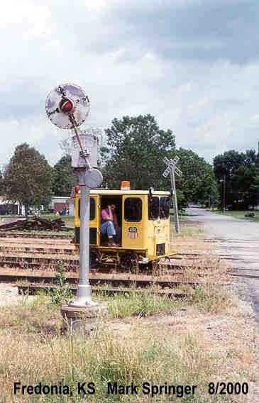
*edit*
This would appear to be it, in it's new home!
Last edited by SirKrunch on Sat Jan 24, 2026 5:24 pm, edited 1 time in total.
Well,
Re: Tracks out of service
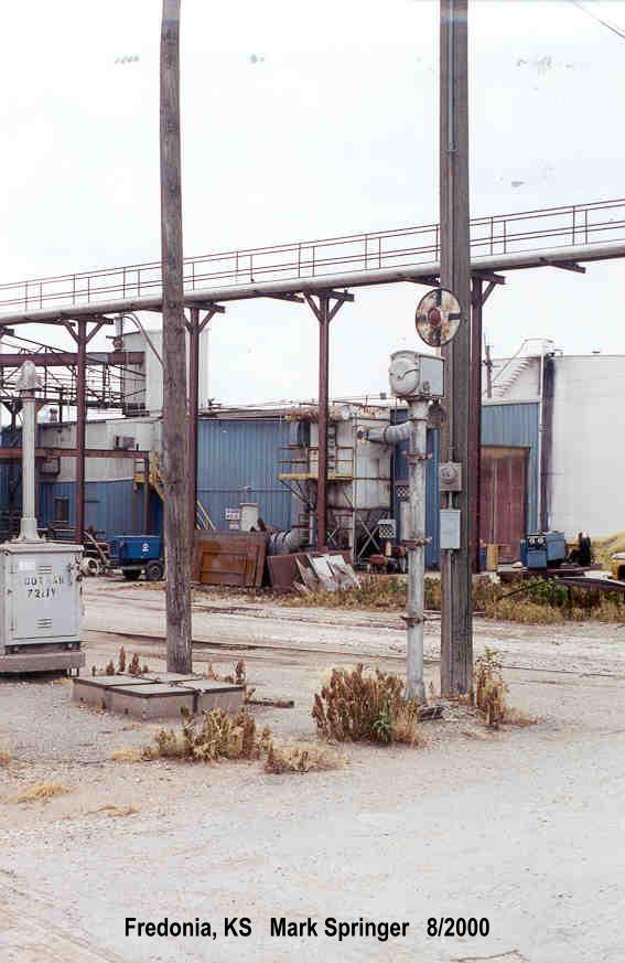
http://www.trainweb.org/dansrailpix/fredonia1.JPGAndyWS wrote: Fri Jan 23, 2026 1:40 am The next crossing south on the ex-Santa Fe has another orphaned relay case and battery box:
https://maps.app.goo.gl/6hAmL8Wv3Xn3FFnM9
Well,
Re: Tracks out of service
Oh, wow. So the one I thought might have once been a wigwag (probably) wasn't, but the other two were?! Thanks for that info!SirKrunch wrote: Sat Jan 24, 2026 5:13 pmAndyWS wrote: Fri Jan 23, 2026 1:40 am Continuing south, this crossing has a relay case with a wire still going to it and the concrete remains of a battery box, but no traces of signals, just crossbucks on wooden posts. Looking at the history, that was the case back in 2014, as well.
https://maps.app.goo.gl/en6quxQdxnrfrNbm6
Looked over a couple photos on Dan's Wig Wag Site. I really feel like the wrong street name (Harrison) is applied to this image and belongs to this (Jackson) crossing. Especially if you look at the 2014 streetview and note the position of a prominent street lamp in the image.
http://www.trainweb.org/dansrailpix/fredonia2.JPG
*edit*
This would appear to be it, in it's new home!
Badgerland Rail Videos: https://www.youtube.com/@BadgerlandRailVideos
Rail photos: https://flickr.com/photos/andywskies/albums
Rail photos: https://flickr.com/photos/andywskies/albums
-
freebrickproductions
- Posts: 9483
- Joined: Thu Jun 07, 2012 11:12 am
- Location: Huntsville, AL
- Contact:
Re: Tracks out of service
Found some abandoned late-SOU signals in High Point, NC:
https://www.google.com/maps/@35.9380926 ... FQAw%3D%3D
https://www.google.com/maps/@35.9380926 ... FQAw%3D%3D
They/Them for me, please.
Click here if you want to submit crossing photos to the site!
Avatar by runesprite on Twitter.
Click here if you want to submit crossing photos to the site!
Avatar by runesprite on Twitter.