I decided to bring this back.I found an abandoned train and line.
http://www.artificialowl.net/2008/08/la ... rains.html
I have abandoned lines on this link.
http://flickr.com/photos/28801928@N07/s ... 680882155/
abandoned lines
Moderators: freebrickproductions, mlgillson, PlyingKibbles89, Raco_GS, Hopen111, TommyBNSF
-
legsbluetrain

- Posts: 751
- kuchnie-na-wymiar.wroclaw.pl
- Joined: Fri Feb 20, 2009 6:47 pm
- Location: Pine Bluff,AR
- Contact:
abandoned lines
Last edited by legsbluetrain on Wed Feb 25, 2009 1:49 am, edited 1 time in total.
Re: abandined lines
Fix the title, please. 
Yeah, this was a good discussion. Exploring and documenting leftover railroad infrastructure on abandoned lines is one of my favorite aspects of railfanning, unfortunately most of the time there's not much left.
I'm going to repost the link to Brent's excellent Photobucket galleries of the abandoned crossings in the Milwaukee area:
http://s50.photobucket.com/albums/f306/ ... /Railroad/
Say Brent, didn't you used to have some pictures of the R&SW in there?
Badgerland Rail Videos: https://www.youtube.com/@BadgerlandRailVideos
Rail photos: https://flickr.com/photos/andywskies/albums
Rail photos: https://flickr.com/photos/andywskies/albums
-
legsbluetrain
- Posts: 751
- Joined: Fri Feb 20, 2009 6:47 pm
- Location: Pine Bluff,AR
- Contact:
Re: abandined lines
Thanks.I fixed that typo.AndyWS wrote:Fix the title, please.
Yeah, this was a good discussion. Exploring and documenting leftover railroad infrastructure on abandoned lines is one of my favorite aspects of railfanning, unfortunately most of the time there's not much left.
I'm going to repost the link to Brent's excellent Photobucket galleries of the abandoned crossings in the Milwaukee area:
http://s50.photobucket.com/albums/f306/ ... /Railroad/
Say Brent, didn't you used to have some pictures of the R&SW in there?
Re: abandined lines
The R&SW Division photos are on flickr:AndyWS wrote:
I'm going to repost the link to Brent's excellent Photobucket galleries of the abandoned crossings in the Milwaukee area:
http://s50.photobucket.com/albums/f306/ ... /Railroad/
Say Brent, didn't you used to have some pictures of the R&SW in there?
http://www.flickr.com/photos/bmgpx/sets ... 145157909/
-
illinoistrains

- Posts: 664
- Joined: Fri Jan 30, 2009 11:32 pm
- Location: Glendale, AZ
- Contact:
Re: abandoned lines
You can see part of the former IC 2nd track in Divernon IL, removed aroung 1985, they just cut the rails off at the crossings. This crossing had a wigwag untill 1999.
http://maps.google.com/?ie=UTF8&ll=39.5 ... 8235294126
Here is a bridge from the former C&NW tracks east of west of Girard, IL. this track was removed around 1998/1999.
http://maps.google.com/?ie=UTF8&ll=39.4 ... 7058823529
here is one of the crossings, i do remember seeing the end of a train here once around 1998.
http://maps.google.com/?ie=UTF8&ll=39.4 ... 8235294108
another former crossing:
http://maps.google.com/?ie=UTF8&ll=39.4 ... 0588235274
and finally a picture of the line in use! one of the comments is mine.
http://www.rrpicturearchives.net/showPi ... id=1013065
Visit my website to see my complete collection of over 2,200 train pictures:
http://cnfan1.rrpicturearchives.net/
http://cnfan1.rrpicturearchives.net/
Ghost Rails of Milwaukeeland
I did some photography of the numerous abandoned lines with track segments still intact (but heavily overgrown) that exist around the Milwaukee metro area today.

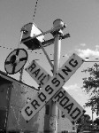
Above is the west side of the former crossing at Springdale Road between Brookfield and Waukesha. This was part of the Milwaukee Road's first mainline west across Wisconsin, but eventually became secondary to the Twin Cities mainline to the north (which it connects to at Brookfield). The part of the line between Brookfield and Waukesha has some track intact, but heavily overgrown and with the crossings removed, as here. The FRA report lists the closure of the crossing as occuring in 1995. The diamond over the Soo Line (now CN) north-south mainline in Waukesha is gone. On the west side of Waukesha the WSOR gets on the remainder of the line, using a segment of the old C&NW to connect to their trackage rights on the CN (old Soo). Things sure can get complex when three railroads build through one town. From there all the way west to Prairie du Chien, the WSOR operates the rest of the original line.
Below are more views looking west:


Closeups of the rail:


Looking east:


Looking back west again:

Thanks to Brent for calling my attention to this next one:


This is the remains of the CP's (also ex-Milwaukee Road) West Allis line at the Blue Mound Road (Highway 18) crossing. The crossing was put out of service after the last customer seen in the top picture no longer required service. The rest of the line in the far distance of the picture is already gone.
The top picture looks southeast, and the bottom one looks northwest at the crossing. Google Street View shows the signals that used to be here, 12" x 24", ungated signals with three cantilevers and a mast signal:
http://maps.google.com/?ie=UTF8&ll=43.0 ... 7142857135
http://maps.google.com/?ie=UTF8&ll=43.0 ... 8571428572
http://maps.google.com/?ie=UTF8&ll=43.0 ... 0000000008
http://maps.google.com/?ie=UTF8&ll=43.0 ... 1428571428
http://maps.google.com/?ie=UTF8&ll=43.0 ... 4285714288
http://maps.google.com/?ie=UTF8&ll=43.0 ... 5714285738
The next picture looks south at the remains of the Green Bay Road (Highway 57) crossing of the WSOR (again ex-Milwaukee Road) "Beer Line".

On Google Street View, we can see that two 8" signals used to guard this side of the crossing, one of them a Griswold Type B:
http://maps.google.com/?ie=UTF8&ll=43.0 ... 8571428594
The next three pictures show the remains of the rails and right-of-way blocked by a dirt pile looking northwest:


We see the same view on GSV with the track still in:
http://maps.google.com/?ie=UTF8&ll=43.0 ... 7142857166
This next picture and street view look southeast across the road:

http://maps.google.com/?ie=UTF8&ll=43.0 ... 1428571452
An 8" signal and a 12" x 24" signal once stood facing the northbound lanes of the crossing:
http://maps.google.com/?ie=UTF8&ll=43.0 ... 5714285715
The next pictures are of the same Union Pacific (ex-Chicago and Northwestern) line Brent took pictures of.
This is looking south on Estabrook Parkway:

Looking northeast:


Looking southwest:

This is the crossing at Hampton Avenue looking northwest at the remains of an 8" Safetran signal for westbound traffic:

The below picture looks south. You can see a switch stand and points where the spur that crosses Estabrook Parkway branches off, not visible in Brent's picture because of the summer leaves on the overgrowing shrubbery. The line going straight ahead was once a C&NW passenger main. It ends a short distance beyond in the woods, and much of the right-of-way south of here has been developed into a trail.

Looking north:

The signal relay case:

More shots of the westbound signal, which is missing one front light and has one of the rear ones twisted upward and the background broken:


The eastbound signal, which has a Safetran mechanical bell, is also missing a front light:

Brent, if you ever catch wind that they're going to pull this stuff out, might not be a bad time to try and snag yourself some 8" Safetran lights and a bell.
Above is the west side of the former crossing at Springdale Road between Brookfield and Waukesha. This was part of the Milwaukee Road's first mainline west across Wisconsin, but eventually became secondary to the Twin Cities mainline to the north (which it connects to at Brookfield). The part of the line between Brookfield and Waukesha has some track intact, but heavily overgrown and with the crossings removed, as here. The FRA report lists the closure of the crossing as occuring in 1995. The diamond over the Soo Line (now CN) north-south mainline in Waukesha is gone. On the west side of Waukesha the WSOR gets on the remainder of the line, using a segment of the old C&NW to connect to their trackage rights on the CN (old Soo). Things sure can get complex when three railroads build through one town. From there all the way west to Prairie du Chien, the WSOR operates the rest of the original line.
Below are more views looking west:
Closeups of the rail:
Looking east:
Looking back west again:
Thanks to Brent for calling my attention to this next one:
This is the remains of the CP's (also ex-Milwaukee Road) West Allis line at the Blue Mound Road (Highway 18) crossing. The crossing was put out of service after the last customer seen in the top picture no longer required service. The rest of the line in the far distance of the picture is already gone.
The top picture looks southeast, and the bottom one looks northwest at the crossing. Google Street View shows the signals that used to be here, 12" x 24", ungated signals with three cantilevers and a mast signal:
http://maps.google.com/?ie=UTF8&ll=43.0 ... 7142857135
http://maps.google.com/?ie=UTF8&ll=43.0 ... 8571428572
http://maps.google.com/?ie=UTF8&ll=43.0 ... 0000000008
http://maps.google.com/?ie=UTF8&ll=43.0 ... 1428571428
http://maps.google.com/?ie=UTF8&ll=43.0 ... 4285714288
http://maps.google.com/?ie=UTF8&ll=43.0 ... 5714285738
The next picture looks south at the remains of the Green Bay Road (Highway 57) crossing of the WSOR (again ex-Milwaukee Road) "Beer Line".
On Google Street View, we can see that two 8" signals used to guard this side of the crossing, one of them a Griswold Type B:
http://maps.google.com/?ie=UTF8&ll=43.0 ... 8571428594
The next three pictures show the remains of the rails and right-of-way blocked by a dirt pile looking northwest:
We see the same view on GSV with the track still in:
http://maps.google.com/?ie=UTF8&ll=43.0 ... 7142857166
This next picture and street view look southeast across the road:
http://maps.google.com/?ie=UTF8&ll=43.0 ... 1428571452
An 8" signal and a 12" x 24" signal once stood facing the northbound lanes of the crossing:
http://maps.google.com/?ie=UTF8&ll=43.0 ... 5714285715
The next pictures are of the same Union Pacific (ex-Chicago and Northwestern) line Brent took pictures of.
This is looking south on Estabrook Parkway:
Looking northeast:
Looking southwest:
This is the crossing at Hampton Avenue looking northwest at the remains of an 8" Safetran signal for westbound traffic:
The below picture looks south. You can see a switch stand and points where the spur that crosses Estabrook Parkway branches off, not visible in Brent's picture because of the summer leaves on the overgrowing shrubbery. The line going straight ahead was once a C&NW passenger main. It ends a short distance beyond in the woods, and much of the right-of-way south of here has been developed into a trail.
Looking north:
The signal relay case:
More shots of the westbound signal, which is missing one front light and has one of the rear ones twisted upward and the background broken:
The eastbound signal, which has a Safetran mechanical bell, is also missing a front light:
Brent, if you ever catch wind that they're going to pull this stuff out, might not be a bad time to try and snag yourself some 8" Safetran lights and a bell.
Badgerland Rail Videos: https://www.youtube.com/@BadgerlandRailVideos
Rail photos: https://flickr.com/photos/andywskies/albums
Rail photos: https://flickr.com/photos/andywskies/albums
Re: Ghost Rails of Milwaukeeland
Looks like somebody already had that idea!AndyWS wrote: Brent, if you ever catch wind that they're going to pull this stuff out, might not be a bad time to try and snag yourself some 8" Safetran lights and a bell.
Re: abandoned lines
If so, they sure half-@$$ed it! Must have only needed 2 lights to complete their setup, or else they didn't have the right tools and quit after removing 2 lights and busting up another, 'cause the cops were coming.
At this point UP might be willing to just give them away, with permission.
At this point UP might be willing to just give them away, with permission.
Badgerland Rail Videos: https://www.youtube.com/@BadgerlandRailVideos
Rail photos: https://flickr.com/photos/andywskies/albums
Rail photos: https://flickr.com/photos/andywskies/albums
-
Crossingman18
- Posts: 569
- Joined: Sat Jan 31, 2009 9:11 pm
- Location: Mobile, AL. ALWAYS WILL BE A MAINE RAILFAN!
- Contact:
Re: abandoned lines
ya know if we are bringing signals into this topic, we should make the topic name just like the one in the old forum, Abandoned lines and closed Crossings

Rest In Peace Guilford SD26 615!
Re: abandoned lines
Didn't anybody ever tell you to pick your signals up when you're done with them? 
http://maps.google.com/?ie=UTF8&ll=40.3 ... 9574121954
http://maps.google.com/?ie=UTF8&ll=40.3 ... 5814555065
http://maps.google.com/?ie=UTF8&ll=40.3 ... 2957412206
http://maps.google.com/?ie=UTF8&ll=40.3 ... 6528840785
http://maps.google.com/?ie=UTF8&ll=40.3 ... 9574121954
http://maps.google.com/?ie=UTF8&ll=40.3 ... 5814555065
http://maps.google.com/?ie=UTF8&ll=40.3 ... 2957412206
http://maps.google.com/?ie=UTF8&ll=40.3 ... 6528840785
Badgerland Rail Videos: https://www.youtube.com/@BadgerlandRailVideos
Rail photos: https://flickr.com/photos/andywskies/albums
Rail photos: https://flickr.com/photos/andywskies/albums