Google Street View

Talk about other non-signal stuff here. Make sure to obey the rules though.

Moderators: freebrickproductions, mlgillson, PlyingKibbles89, Raco_GS, Hopen111, TommyBNSF

User avatar
ToledoRailfan
No Longer Associated With The Forum
Posts: 3315
kuchnie-na-wymiar.wroclaw.pl
Joined: Sun Jul 21, 2013 2:38 pm

Re: Google Street View

Post by ToledoRailfan »

freebrickproductions wrote:
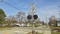
ToledoRailfan wrote:Very short signal!
That's due to an airport being right over here:
https://www.google.com/maps/@40.9746601 ... 6656?hl=en
I never understood why they do that. It isn't often that a plane would be low a enough to hit something like that outside of the airport. And if having a signal that low can work for the railroad, why don't they just do that for most signals. :Confused:
User avatar
freebrickproductions
Posts: 9377
Joined: Thu Jun 07, 2012 11:12 am
Location: Huntsville, AL
Contact:

Re: Google Street View

Post by freebrickproductions »

ToledoRailfan wrote:
freebrickproductions wrote:
ToledoRailfan wrote:Very short signal!
That's due to an airport being right over here:
https://www.google.com/maps/@40.9746601 ... 6656?hl=en
I never understood why they do that. It isn't often that a plane would be low a enough to hit something like that outside of the airport. And if having a signal that low can work for the railroad, why don't they just do that for most signals. :Confused:
Visibility reasons. Easier to see signals that are as high as the cab if not higher.
They/Them for me, please.

Click here if you want to submit crossing photos to the site!

Avatar by runesprite on Twitter.
User avatar
ToledoRailfan
No Longer Associated With The Forum
Posts: 3315
Joined: Sun Jul 21, 2013 2:38 pm

Re: Google Street View

Post by ToledoRailfan »

freebrickproductions wrote:
ToledoRailfan wrote:
freebrickproductions wrote:
ToledoRailfan wrote:Very short signal!
That's due to an airport being right over here:
https://www.google.com/maps/@40.9746601 ... 6656?hl=en
I never understood why they do that. It isn't often that a plane would be low a enough to hit something like that outside of the airport. And if having a signal that low can work for the railroad, why don't they just do that for most signals. :Confused:
Visibility reasons. Easier to see signals that are as high as the cab if not higher.
I guess this was a "close enough" situation.
User avatar
NathanFromEngland
Posts: 2377
Joined: Sat Apr 29, 2017 3:52 pm
Location: Merseyside

Re: Google Street View

Post by NathanFromEngland »

I wonder why the word "WABASH" is written on this bridge. :Confused:
https://www.google.com/maps/@41.0710692 ... 6656?hl=en
Refer to me as 'Nari' - He/She are my preferred pronouns
User avatar
ToledoRailfan
No Longer Associated With The Forum
Posts: 3315
Joined: Sun Jul 21, 2013 2:38 pm

Re: Google Street View

Post by ToledoRailfan »

NathanFromEngland wrote:I wonder why the word "WABASH" is written on this bridge. :Confused:
https://www.google.com/maps/@41.0710692 ... 6656?hl=en
Probably because it was installed by the Wabash Railroad.
User avatar
freebrickproductions
Posts: 9377
Joined: Thu Jun 07, 2012 11:12 am
Location: Huntsville, AL
Contact:

Re: Google Street View

Post by freebrickproductions »

ToledoRailfan wrote:
NathanFromEngland wrote:I wonder why the word "WABASH" is written on this bridge. :Confused:
https://www.google.com/maps/@41.0710692 ... 6656?hl=en
Probably because it was installed by the Wabash Railroad.
That's most likely the case. Railroads that built/owned the bridges over roads would usually put their name on the sides of them years ago. A few examples that I'm aware of:
Faded SCL emblems on a bridge along the ATN in Attalla:
https://www.google.com/maps/@34.0184691 ... 312!8i6656
https://www.google.com/maps/@34.0187362 ... 312!8i6656

Also note that there's actually two bridges there, despite there only being one track. That's because it used to be an NC&StL (later L&N) main line.

Hard to tell, but it looks like the NS bridge right up the street in Attalla may have said "Southern" on it once upon a time, though it's very hard to tell:
https://www.google.com/maps/@34.0212686 ... 312!8i6656

An Amtrak logo on this bridge in Birmingham, likely due to the proximity to the old and new Amtrak stations there:
https://www.google.com/maps/@33.5122343 ... 312!8i6656

Some kind of faded logo on this bridge in Birmingham, but the L&N's logo can still be seen:
https://www.google.com/maps/@33.4983191 ... 312!8i6656
The one on the other side hasn't held up as well:
https://www.google.com/maps/@33.4985957 ... 312!8i6656

And this bridge in Irondale (also along the ATN) has some old SAL emblems on it:
https://www.google.com/maps/@33.5369281 ... 312!8i6656
https://www.google.com/maps/@33.5371709 ... 312!8i6656

Over in Atlanta, GA, the Atlanta & Westpoint Railroad's marking is still very much legible on this bridge:
https://www.google.com/maps/@33.719742, ... 312!8i6656
The same can't be said for the other side however, sadly:
https://www.google.com/maps/@33.7193081 ... 312!8i6656

This one hasn't fared well either:
https://www.google.com/maps/@33.7205745 ... 312!8i6656
https://www.google.com/maps/@33.7203037 ... 312!8i6656

And then along the section of the line near Downtown Atlanta, you've got this pair of SCL emblems along a remaining bridge:
https://www.google.com/maps/@33.7642444 ... 312!8i6656
https://www.google.com/maps/@33.7642492 ... 312!8i6656

There was something written on this CSX bridge in Nashville, TN:
https://www.google.com/maps/@36.1697107 ... 312!8i6656
https://www.google.com/maps/@36.1700071 ... 312!8i6656

Also in Nashville, "Georgia RR"?
https://www.google.com/maps/@36.1393774 ... 312!8i6656
https://www.google.com/maps/@36.1396444 ... 312!8i6656

And finally, "CSX Transportation" in Nashville:
https://www.google.com/maps/@36.0884937 ... 312!8i6656
https://www.google.com/maps/@36.0887009 ... 312!8i6656
They/Them for me, please.

Click here if you want to submit crossing photos to the site!

Avatar by runesprite on Twitter.
User avatar
ZachL
Posts: 3029
Joined: Mon Dec 17, 2012 4:04 pm
Location: Hillsborough County/Tampa, FL

Re: Google Street View

Post by ZachL »

Sometimes you can find old railroad names on equipment, too. Not sure if SCL always did this, but a lot of equipment on the Port Tampa spur still has SCL markings on them:
https://www.google.com/maps/@27.9191797 ... 312!8i6656
Crossing pictures from Plant City, FL are finally here! viewtopic.php?f=13&t=2538
User avatar
NathanFromEngland
Posts: 2377
Joined: Sat Apr 29, 2017 3:52 pm
Location: Merseyside

Re: Google Street View

Post by NathanFromEngland »

Refer to me as 'Nari' - He/She are my preferred pronouns
User avatar
freebrickproductions
Posts: 9377
Joined: Thu Jun 07, 2012 11:12 am
Location: Huntsville, AL
Contact:

Re: Google Street View

Post by freebrickproductions »

"Low Rat" at this motel along the Parkway here in Huntsville:
https://www.google.com/maps/@34.7452173 ... 312!8i6656
Just the one rat though.
They/Them for me, please.

Click here if you want to submit crossing photos to the site!

Avatar by runesprite on Twitter.
User avatar
ToledoRailfan
No Longer Associated With The Forum
Posts: 3315
Joined: Sun Jul 21, 2013 2:38 pm

Re: Google Street View

Post by ToledoRailfan »

freebrickproductions wrote: Just the one rat though.
*For each room.

They're complementary! :LOL:
Post Reply