I wouldn't be surprised if that was someone's edit that made it through Google Map Maker. I remember a few years ago on Google Map Maker when you would create a trail, it would automatically get approved after you submit it.
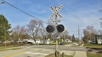
Yeah... both of those cantilevers seem like they are placed way too far down. It would have been interesting to see where people stopped when the signals were active.
Yeah... both of those cantilevers seem like they are placed way too far down. It would have been interesting to see where people stopped when the signals were active.
Yeah... both of those cantilevers seem like they are placed way too far down. It would have been interesting to see where people stopped when the signals were active.